Chappes, Allier
Chappes (French pronunciation: [ʃap]; Occitan: Chapas) is a commune in the Allier department in central France.
Chappes | |
|---|---|
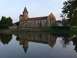 The church in Chappes | |
Location of Chappes  | |
 Chappes  Chappes | |
| Coordinates: 46°23′19″N 2°55′38″E | |
| Country | France |
| Region | Auvergne-Rhône-Alpes |
| Department | Allier |
| Arrondissement | Montluçon |
| Canton | Commentry |
| Intercommunality | Commentry Montmarault Néris Communauté |
| Government | |
| • Mayor (2020–2026) | Élisabeth Blanchet[1] |
| Area 1 | 18.6 km2 (7.2 sq mi) |
| Population | 238 |
| • Density | 13/km2 (33/sq mi) |
| Time zone | UTC+01:00 (CET) |
| • Summer (DST) | UTC+02:00 (CEST) |
| INSEE/Postal code | 03058 /03390 |
| Elevation | 290–436 m (951–1,430 ft) (avg. 410 m or 1,350 ft) |
| 1 French Land Register data, which excludes lakes, ponds, glaciers > 1 km2 (0.386 sq mi or 247 acres) and river estuaries. | |
Population
| Year | Pop. | ±% |
|---|---|---|
| 1962 | 308 | — |
| 1968 | 352 | +14.3% |
| 1975 | 307 | −12.8% |
| 1982 | 240 | −21.8% |
| 1990 | 219 | −8.8% |
| 1999 | 221 | +0.9% |
| 2008 | 203 | −8.1% |
| 2012 | 204 | +0.5% |
See also
References
- "Liste nominative des communes de l'Allier" [Nominative list of communes of Allier] (PDF) (in French). Association of Mayors and Presidents of Communities of Allier. 8 July 2020. Retrieved 6 December 2020.
- "Populations légales 2019". The National Institute of Statistics and Economic Studies. 29 December 2021.
| Wikimedia Commons has media related to Chappes. |
This article is issued from Wikipedia. The text is licensed under Creative Commons - Attribution - Sharealike. Additional terms may apply for the media files.