Chantelle, Allier
Chantelle (French pronunciation: [ʃɑ̃tɛl]; Occitan: Chantela) is a commune in the Allier department in central France.
Chantelle | |
|---|---|
 The abbey in Chantelle | |
.svg.png.webp) Coat of arms | |
Location of Chantelle 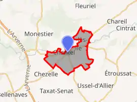 | |
 Chantelle  Chantelle | |
| Coordinates: 46°14′20″N 3°09′14″E | |
| Country | France |
| Region | Auvergne-Rhône-Alpes |
| Department | Allier |
| Arrondissement | Moulins |
| Canton | Gannat |
| Intercommunality | Saint-Pourçain Sioule Limagne |
| Government | |
| • Mayor (2020–2026) | André Bidaud[1] (PR) |
| Area 1 | 10.96 km2 (4.23 sq mi) |
| Population | 1,102 |
| • Density | 100/km2 (260/sq mi) |
| Time zone | UTC+01:00 (CET) |
| • Summer (DST) | UTC+02:00 (CEST) |
| INSEE/Postal code | 03053 /03140 |
| Elevation | 258–349 m (846–1,145 ft) (avg. 324 m or 1,063 ft) |
| 1 French Land Register data, which excludes lakes, ponds, glaciers > 1 km2 (0.386 sq mi or 247 acres) and river estuaries. | |
Geography
The village lies on the right bank of the Bouble, which forms most of the commune's northern border.
Population
| Year | Pop. | ±% |
|---|---|---|
| 1962 | 1,095 | — |
| 1968 | 1,121 | +2.4% |
| 1975 | 1,069 | −4.6% |
| 1982 | 1,084 | +1.4% |
| 1990 | 1,043 | −3.8% |
| 1999 | 1,040 | −0.3% |
| 2008 | 1,062 | +2.1% |
| 2012 | 1,069 | +0.7% |
See also
References
- "Liste nominative des communes de l'Allier" [Nominative list of communes of Allier] (PDF) (in French). Association of Mayors and Presidents of Communities of Allier. 8 July 2020. Retrieved 6 December 2020.
- "Populations légales 2019". The National Institute of Statistics and Economic Studies. 29 December 2021.
External links
| Wikimedia Commons has media related to Chantelle. |
- Official Web site (in French)
This article is issued from Wikipedia. The text is licensed under Creative Commons - Attribution - Sharealike. Additional terms may apply for the media files.