Laviron
Laviron (French pronunciation: [laviʁɔ̃]) is a commune in the Doubs department in the Bourgogne-Franche-Comté region in eastern France.
Laviron | |
|---|---|
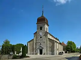 The church in Laviron | |
.svg.png.webp) Coat of arms | |
Location of Laviron  | |
 Laviron  Laviron | |
| Coordinates: 47°15′24″N 6°33′10″E | |
| Country | France |
| Region | Bourgogne-Franche-Comté |
| Department | Doubs |
| Arrondissement | Pontarlier |
| Canton | Valdahon |
| Government | |
| • Mayor (2020–2026) | Régis Bouchard[1] |
| Area 1 | 19.92 km2 (7.69 sq mi) |
| Population | 343 |
| • Density | 17/km2 (45/sq mi) |
| Time zone | UTC+01:00 (CET) |
| • Summer (DST) | UTC+02:00 (CEST) |
| INSEE/Postal code | 25333 /25510 |
| Elevation | 658–853 m (2,159–2,799 ft) |
| 1 French Land Register data, which excludes lakes, ponds, glaciers > 1 km2 (0.386 sq mi or 247 acres) and river estuaries. | |
Geography
The commune is situated 5 km (3.1 mi) from Pierrefontaine-les-Varans.
Population
| Year | Pop. | ±% |
|---|---|---|
| 1962 | 463 | — |
| 1968 | 475 | +2.6% |
| 1975 | 415 | −12.6% |
| 1982 | 380 | −8.4% |
| 1990 | 347 | −8.7% |
| 1999 | 331 | −4.6% |
| 2008 | 341 | +3.0% |
| 2012 | 355 | +4.1% |
See also
References
- "Répertoire national des élus: les maires". data.gouv.fr, Plateforme ouverte des données publiques françaises (in French). 2 December 2020.
- "Populations légales 2019". The National Institute of Statistics and Economic Studies. 29 December 2021.
External links
| Wikimedia Commons has media related to Laviron. |
This article is issued from Wikipedia. The text is licensed under Creative Commons - Attribution - Sharealike. Additional terms may apply for the media files.