Dienne
Dienne (French pronunciation: [djɛn]; Occitan: Dièna or Diana) is a commune in the Cantal department, southcentral France.
Dienne | |
|---|---|
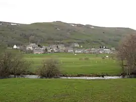 A general view of Dienne | |
.svg.png.webp) Coat of arms | |
Location of Dienne  | |
 Dienne  Dienne | |
| Coordinates: 45°09′34″N 2°47′16″E | |
| Country | France |
| Region | Auvergne-Rhône-Alpes |
| Department | Cantal |
| Arrondissement | Saint-Flour |
| Canton | Murat |
| Intercommunality | Hautes Terres |
| Government | |
| • Mayor (2020–2026) | Thierry Mathieu[1] |
| Area 1 | 46.33 km2 (17.89 sq mi) |
| Population | 272 |
| • Density | 5.9/km2 (15/sq mi) |
| Time zone | UTC+01:00 (CET) |
| • Summer (DST) | UTC+02:00 (CEST) |
| INSEE/Postal code | 15061 /15300 |
| Elevation | 1,015–1,561 m (3,330–5,121 ft) (avg. 1,050 m or 3,440 ft) |
| 1 French Land Register data, which excludes lakes, ponds, glaciers > 1 km2 (0.386 sq mi or 247 acres) and river estuaries. | |
Population
| Year | Pop. | ±% |
|---|---|---|
| 1962 | 655 | — |
| 1968 | 583 | −11.0% |
| 1975 | 496 | −14.9% |
| 1982 | 396 | −20.2% |
| 1990 | 359 | −9.3% |
| 1999 | 293 | −18.4% |
| 2008 | 255 | −13.0% |
See also
References
- "Répertoire national des élus: les maires". data.gouv.fr, Plateforme ouverte des données publiques françaises (in French). 9 August 2021.
- "Populations légales 2019". The National Institute of Statistics and Economic Studies. 29 December 2021.
| Wikimedia Commons has media related to Dienne. |
This article is issued from Wikipedia. The text is licensed under Creative Commons - Attribution - Sharealike. Additional terms may apply for the media files.