Serdinya
Serdinya (French pronunciation: [sɛʁdiɲa] (![]() listen); Catalan: Serdinyà) is a commune in the Pyrénées-Orientales department in southern France.
listen); Catalan: Serdinyà) is a commune in the Pyrénées-Orientales department in southern France.
Serdinya
Serdinyà | |
|---|---|
 Serdinya seen from Route nationale 116 | |
.svg.png.webp) Coat of arms | |
Location of Serdinya  | |
 Serdinya  Serdinya | |
| Coordinates: 42°34′08″N 2°19′20″E | |
| Country | France |
| Region | Occitania |
| Department | Pyrénées-Orientales |
| Arrondissement | Prades |
| Canton | Les Pyrénées catalanes |
| Intercommunality | Conflent-Canigó |
| Government | |
| • Mayor (2020–2026) | Jean-Marie Maydat |
| Area 1 | 16.91 km2 (6.53 sq mi) |
| Population | 232 |
| • Density | 14/km2 (36/sq mi) |
| Time zone | UTC+01:00 (CET) |
| • Summer (DST) | UTC+02:00 (CEST) |
| INSEE/Postal code | 66193 /66360 |
| Elevation | 449–1,792 m (1,473–5,879 ft) (avg. 530 m or 1,740 ft) |
| 1 French Land Register data, which excludes lakes, ponds, glaciers > 1 km2 (0.386 sq mi or 247 acres) and river estuaries. | |
Residents are Serdinya are called Serdinyanais in French and Serdinyanencs in Catalan.
Geography
Localisation
Serdinya is located in the canton of Les Pyrénées catalanes and in the arrondissement of Prades.

Map of Serdinya and its surrounding communes
Transport
Route nationale 116 (RN 116) connecting Perpignan and Bourg-Madame (near the Spanish and Andorran borders) passes through Serdinya.
Politics and administration
Municipal administration
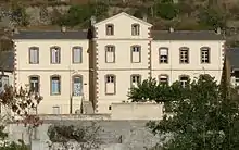
Serdinya town hall.
Population
| Year | Pop. | ±% p.a. |
|---|---|---|
| 1968 | 307 | — |
| 1975 | 271 | −1.77% |
| 1982 | 233 | −2.14% |
| 1990 | 213 | −1.12% |
| 1999 | 233 | +1.00% |
| 2007 | 220 | −0.72% |
| 2012 | 207 | −1.21% |
| 2017 | 246 | +3.51% |
| Source: INSEE[2] | ||
References
| Wikimedia Commons has media related to Serdinya. |
This article is issued from Wikipedia. The text is licensed under Creative Commons - Attribution - Sharealike. Additional terms may apply for the media files.