Saint-Cergues
Saint-Cergues is a commune in the Haute-Savoie department in the Auvergne-Rhône-Alpes region in south-eastern France.
Saint-Cergues | |
|---|---|
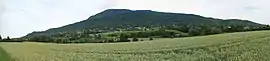 The landscape around Saint-Cergues | |
 Coat of arms | |
Location of Saint-Cergues  | |
 Saint-Cergues  Saint-Cergues | |
| Coordinates: 46°14′08″N 6°19′18″E | |
| Country | France |
| Region | Auvergne-Rhône-Alpes |
| Department | Haute-Savoie |
| Arrondissement | Saint-Julien-en-Genevois |
| Canton | Gaillard |
| Intercommunality | Annemasse – Les Voirons |
| Government | |
| • Mayor (2020–2026) | Gabriel Doublet[1] |
| Area 1 | 12.55 km2 (4.85 sq mi) |
| Population | 3,671 |
| • Density | 290/km2 (760/sq mi) |
| Demonym(s) | Saint-cerguois |
| Time zone | UTC+01:00 (CET) |
| • Summer (DST) | UTC+02:00 (CEST) |
| INSEE/Postal code | 74229 /74140 |
| Elevation | 486–1,480 m (1,594–4,856 ft) |
| 1 French Land Register data, which excludes lakes, ponds, glaciers > 1 km2 (0.386 sq mi or 247 acres) and river estuaries. | |
References
- "Répertoire national des élus: les maires". data.gouv.fr, Plateforme ouverte des données publiques françaises (in French). 2 December 2020.
- "Populations légales 2019". The National Institute of Statistics and Economic Studies. 29 December 2021.
| Wikimedia Commons has media related to Saint-Cergues. |
This article is issued from Wikipedia. The text is licensed under Creative Commons - Attribution - Sharealike. Additional terms may apply for the media files.