Reefs Harbour-Shoal Cove West-New Ferolle
Reefs Harbour-Shoal Cove West-New Ferolle is a local service district and designated place in the Canadian province of Newfoundland and Labrador. It is southwest of Anchor Point.
 | |
 | |
| Location | Reefs Harbour-Shoal Cove West-New Ferolle, Newfoundland and Labrador, Canada |
|---|---|
| Coordinates | 51°01′21″N 57°05′44″W |
| Tower | |
| Constructed | 1913 |
| Construction | concrete (foundation), concrete (tower) |
| Height | 19 m (62 ft) |
| Shape | hexagonal prism tower with six ribs, balcony and lantern[1][2] |
| Markings | white (tower), red (lantern) |
| Power source | mains electricity |
| Operator | Canadian Coast Guard |
| Heritage | recognized federal heritage building of Canada, heritage lighthouse |
| Fog signal | 4s. blast every 56s. |
| Light | |
| Focal height | 27 m (89 ft) |
| Lens | third order Fresnel lens |
| Range | 20 nmi (37 km; 23 mi) |
| Characteristic | Q(4) W 7.5s |
Geography
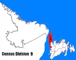
Reefs Harbour-Shoal Cove West-New Ferolle is in Newfoundland within Subdivision C of Division No. 9.[3] The area consists of three unincorporated communities – Reefs Harbour, Shoal Cove and New Ferolle – on the New Ferolle Peninsula near Port au Choix.
Demographics
As a designated place in the 2016 Census of Population conducted by Statistics Canada, Reefs Harbour-Shoal Cove West-New Ferolle recorded a population of 100 living in 53 of its 67 total private dwellings, a change of -56.5% from its 2011 population of 230. With a land area of 11.94 km2 (4.61 sq mi), it had a population density of 8.4/km2 (21.7/sq mi) in 2016.[4]
Government
Reefs Harbour-Shoal Cove West-New Ferolle is a local service district (LSD)[5] that is governed by a committee responsible for the provision of certain services to the community.[6] The chair of the LSD committee is Gloria Tucker.[5]
See also
References
- Rowlett, Russ. "Lighthouses of Canada: Southwestern Newfoundland". The Lighthouse Directory. University of North Carolina at Chapel Hill. Retrieved 2017-02-16.
- List of Lights, Pub. 110: Greenland, The East Coasts of North and South America (Excluding Continental U.S.A. Except the East Coast of Florida) and the West Indies (PDF). List of Lights. United States National Geospatial-Intelligence Agency. 2016.
- "Population and dwelling counts, for Canada, provinces and territories, census divisions, census subdivisions (municipalities) and designated places, 2016 and 2011 censuses – 100% data (Newfoundland and Labrador)". Statistics Canada. February 7, 2018. Retrieved December 23, 2021.
- "Population and dwelling counts, for Canada, provinces and territories, and designated places, 2016 and 2011 censuses – 100% data (Newfoundland and Labrador)". Statistics Canada. February 7, 2018. Retrieved December 22, 2021.
- "Directory of Local Service Districts" (PDF). Government of Newfoundland and Labrador. October 2021. Retrieved January 1, 2022.
- "Local Service Districts – Frequently Asked Questions". Government of Newfoundland and Labrador. Retrieved January 1, 2022.
External links
- Aids to Navigation Canadian Coast Guard
Lighthouses of Canada | |
|---|---|
| British Columbia | |
| Manitoba | |
| New Brunswick |
|
| Newfoundland and Labrador |
|
| Nova Scotia | |
| Ontario | |
| Prince Edward Island |
|
| Quebec | |