Lahoussoye
Lahoussoye is a commune in the Somme department in Hauts-de-France in northern France.
Lahoussoye | |
|---|---|
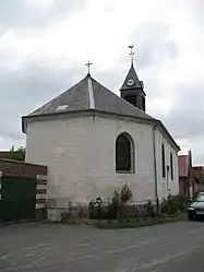 The church in Lahoussoye | |
 Coat of arms | |
Location of Lahoussoye  | |
 Lahoussoye  Lahoussoye | |
| Coordinates: 49°57′08″N 2°28′57″E | |
| Country | France |
| Region | Hauts-de-France |
| Department | Somme |
| Arrondissement | Amiens |
| Canton | Corbie |
| Intercommunality | Val de Somme |
| Government | |
| • Mayor (2020–2026) | Brigitte Leroy[1] |
| Area 1 | 4.09 km2 (1.58 sq mi) |
| Population | 451 |
| • Density | 110/km2 (290/sq mi) |
| Time zone | UTC+01:00 (CET) |
| • Summer (DST) | UTC+02:00 (CEST) |
| INSEE/Postal code | 80458 /80800 |
| Elevation | 55–127 m (180–417 ft) (avg. 122 m or 400 ft) |
| 1 French Land Register data, which excludes lakes, ponds, glaciers > 1 km2 (0.386 sq mi or 247 acres) and river estuaries. | |
Geography
Lahoussoye is situated on the D929 road, about 10 miles (16 km) northeast of Amiens.
Population
| Year | 1962 | 1968 | 1975 | 1982 | 1990 | 1999 | 2006 |
|---|---|---|---|---|---|---|---|
| Population | 175 | 176 | 177 | 225 | 300 | 325 | 334 |
| From the year 1962 on: No double counting—residents of multiple communes (e.g. students and military personnel) are counted only once. | |||||||
See also
References
- "Répertoire national des élus: les maires". data.gouv.fr, Plateforme ouverte des données publiques françaises (in French). 2 December 2020.
- "Populations légales 2019". The National Institute of Statistics and Economic Studies. 29 December 2021.
| Wikimedia Commons has media related to Lahoussoye. |
This article is issued from Wikipedia. The text is licensed under Creative Commons - Attribution - Sharealike. Additional terms may apply for the media files.