Ghyvelde
Ghyvelde (Dutch: Gijvelde, West Flemish: Gyvelde) is a commune in the Nord department in northern France. It is located on the Belgian border, and just inland from the North Sea. It is, after Bray-Dunes, the second most northern commune of France. The E40/A16 passes through the commune. On 1 January 2016, the former commune Les Moëres was merged into Ghyvelde.[2]
Ghyvelde
Gijvelde | |
|---|---|
 Ghyvelde in the arrondissement of Dunkirk | |
_Nord-France.svg.png.webp) Coat of arms | |
Location of Ghyvelde  | |
 Ghyvelde  Ghyvelde | |
| Coordinates: 51°03′08″N 2°31′41″E | |
| Country | France |
| Region | Hauts-de-France |
| Department | Nord |
| Arrondissement | Dunkerque |
| Canton | Dunkerque-2 |
| Intercommunality | Dunkerque |
| Government | |
| • Mayor (2020–2026) | Patrick Theodon |
| Area 1 | 35.92 km2 (13.87 sq mi) |
| Population | 4,131 |
| • Density | 120/km2 (300/sq mi) |
| Demonym(s) | Ghyveldois |
| Time zone | UTC+01:00 (CET) |
| • Summer (DST) | UTC+02:00 (CEST) |
| INSEE/Postal code | 59260 /59254 |
| Elevation | 0–25 m (0–82 ft) (avg. 4 m or 13 ft) |
| 1 French Land Register data, which excludes lakes, ponds, glaciers > 1 km2 (0.386 sq mi or 247 acres) and river estuaries. | |
Gallery
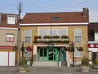 Town hall
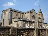 Saint-Vincent church
Heraldry
Arms of Ghyvelde |
The arms of Ghyvelde are blazoned : Ermine, on a bend gules, 3 escallops bendwise Or. (Ghyvelde and Hondschoote use the same arms.)
|
See also
References
- "Populations légales 2019". The National Institute of Statistics and Economic Studies. 29 December 2021.
- Arrêté préfectoral 30 November 2015 (in French)
| Wikimedia Commons has media related to Ghyvelde. |
This article is issued from Wikipedia. The text is licensed under Creative Commons - Attribution - Sharealike. Additional terms may apply for the media files.