Xixia County
Xixia County (simplified Chinese: 西峡; traditional Chinese: 西峽; pinyin: Xīxiá; postal: Sisia) is a county in the southwest of Henan province, China, bordering Shaanxi province to the west. It is under the administration of the prefecture-level city of Nanyang, and has an area of 3,452 km2 (1,333 sq mi) and a population of 420,000 as of 2002.[3]
Xixia County
西峡县 | |
|---|---|
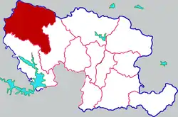 Xixia in Nanyang | |
 Nanyang in Henan (note the map includes the sub-prefectural city of Dengzhou) | |
| Coordinates: 33°18′25″N 111°28′26″E | |
| Country | People's Republic of China |
| Province | Henan |
| Prefecture-level city | Nanyang |
| Area | |
| • Total | 3,453 km2 (1,333 sq mi) |
| Population (2019)[2] | |
| • Total | 431,800 |
| • Density | 130/km2 (320/sq mi) |
| Time zone | UTC+8 (China Standard) |
| Postal code | 474550 |
| Area code(s) | 0377 |
| Website | www |
Administrative divisions
As 2012, this county is divided to 3 subdistricts, 10 towns and 6 townships.[4]
- Subdistricts
- Baiyu Subdistrict (白羽街道)
- Zijin Subdistrict (紫金街道)
- Lianhua Subdistrict (莲花街道)
- Towns
|
|
- Townships
|
|
Transportation
- Hushan Expressway
- China National Highway 209
- China National Highway 311
- China National Highway 312
- Henan Provincial Highway 335
- Yunxi Railway
- Ningxi Railway
References
- 最新人口信息 www.hongheiku.com (in Chinese). hongheiku. Retrieved 2021-01-12.
- 最新人口信息 www.hongheiku.com (in Chinese). hongheiku. Retrieved 2021-01-12.
- "Profile of Xixia County" (in Chinese). Archived from the original on October 13, 2007. Retrieved 2008-06-25.
- 安阳市-行政区划网 www.xzqh.org (in Chinese). XZQH. Retrieved 2012-05-24.
This article is issued from Wikipedia. The text is licensed under Creative Commons - Attribution - Sharealike. Additional terms may apply for the media files.