Wormeldange
Wormeldange (Luxembourgish: Wuermer [ˈvuːɐ̯mɐ] or (locally) Wormer; German: Wormeldingen) is a commune and small town in eastern Luxembourg. It is part of the canton of Grevenmacher.
Wormeldange
Wuermer, Wormer | |
|---|---|
 Wormeldange seen from the nearby chapel Koeppchen | |
 Coat of arms | |
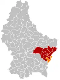 Map of Luxembourg with Wormeldange highlighted in orange, and the canton in dark red | |
| Coordinates: 49.6111°N 6.4056°E | |
| Country | |
| Canton | Grevenmacher |
| Government | |
| • Mayor | Max Hengel (CSV) |
| Area | |
| • Total | 17.25 km2 (6.66 sq mi) |
| • Rank | 68th of 102 |
| Highest elevation | 355 m (1,165 ft) |
| • Rank | 82nd of 102 |
| Lowest elevation | 137 m (449 ft) |
| • Rank | 3rd of 102 |
| Population (2018) | |
| • Total | 2,836 |
| • Rank | 52nd of 102 |
| • Density | 160/km2 (430/sq mi) |
| • Rank | 46th of 102 |
| Time zone | UTC+1 (CET) |
| • Summer (DST) | UTC+2 (CEST) |
| LAU 2 | LU0001108 |
| Website | wormeldange.lu |
As of 2005, the town of Wormeldange, which lies in the south of the commune, has a population of 742. Other towns within the commune include Ahn, Ehnen, Machtum, and Wormeldange-Haut.
Population
References
- "WORMELDANGE - Syvicol". www.syvicol.lu. Retrieved 3 April 2019.
- "Population par canton et commune". statistiques.public.lu. Retrieved 11 January 2022.
{{cite web}}: CS1 maint: url-status (link)
External links
 Media related to Wormeldange at Wikimedia Commons
Places adjacent to Wormeldange | ||||||||||||||||
|---|---|---|---|---|---|---|---|---|---|---|---|---|---|---|---|---|
| ||||||||||||||||
 | ||
This article is issued from Wikipedia. The text is licensed under Creative Commons - Attribution - Sharealike. Additional terms may apply for the media files.