West Muna Regency
West Muna Regency (Indonesian: Kabupaten Muna Barat) is a new regency of Southeast Sulawesi, Indonesia, established under Act No.14 of 2014, dated 23 July 2014 by separation from the Muna Regency. It covers an area of 906.28 km2, and the districts comprising it had a population of 71,632 at the 2010 Census;[3] the 2020 Census resulted in a population of 84,590.[4] The administrative centre lies at Laworo. [5]
West Muna Regency
Kabupaten Muna Barat | |
|---|---|
 Coat of arms | |
| Motto(s): Wite Barakati | |
 Location within Southeast Sulawesi | |
| Coordinates: 4.7900362°S 122.4966354°E | |
| Country | Indonesia |
| Region | Sulawesi |
| Province | Southeast Sulawesi |
| Established | 24 July 2014[1] |
| Founded by | Government of Indonesia |
| Capital | Laworo |
| Government | |
| • Regent | Laode Muhammad Rajiun Tumada |
| • Vice Regent | Ahmad Lamani |
| Area | |
| • Total | 906.28 km2 (349.92 sq mi) |
| Population (2020 Census)[2] | |
| • Total | 84,590 |
| • Density | 93/km2 (240/sq mi) |
| Time zone | UTC+8 (ICST) |
| Area code | (+62) 403 |
| Website | munabaratkab |


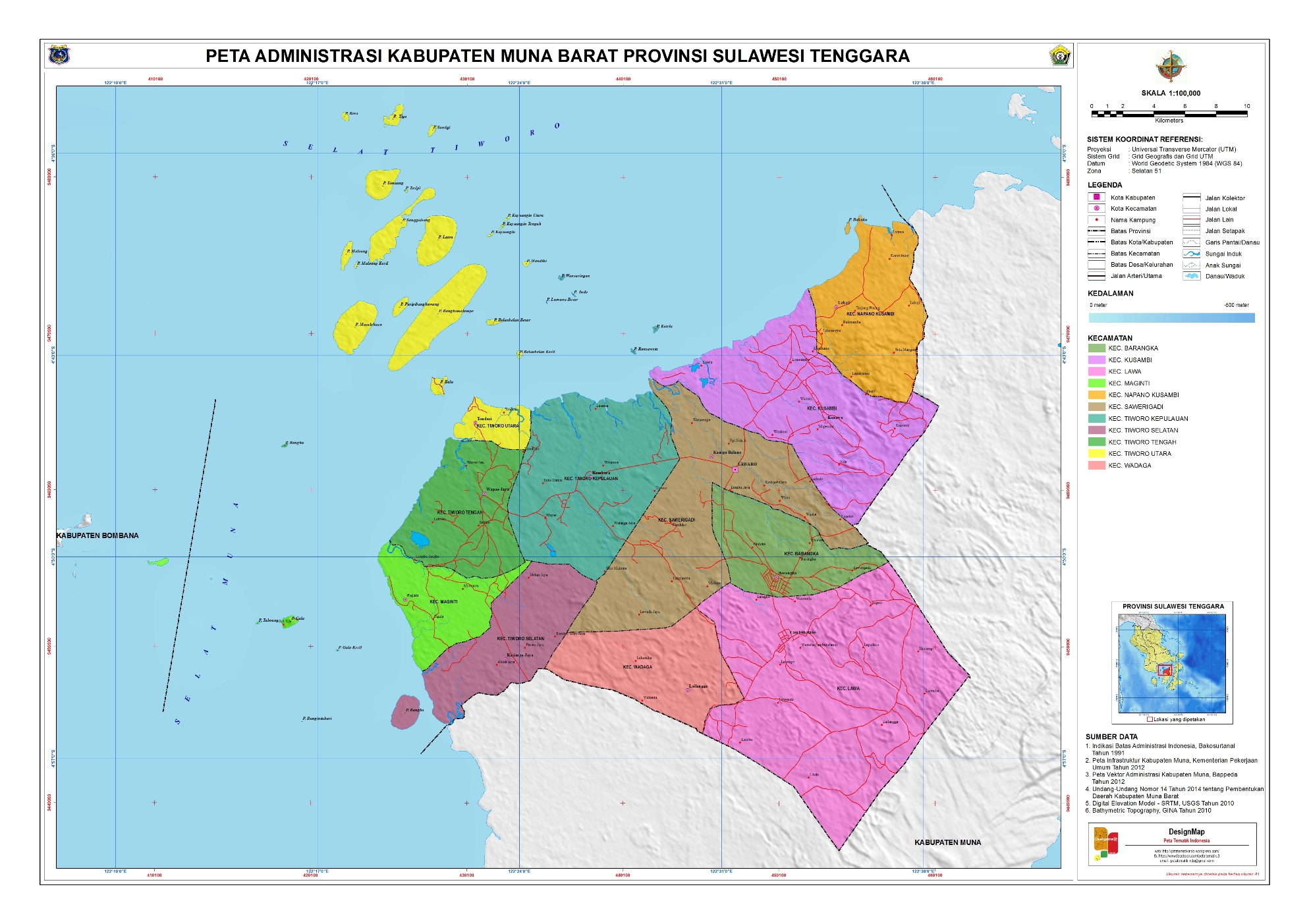
Administrative districts
The West Muna Regency is divided into eleven districts (kecamatan),[6] tabulated below with their areas and their populations at the 2010 Census[7] and the 2020 Census.[8] The table also includes the location of the district headquarters, the number of administrative villages (rural desa and urban kelurahan) in each district, and its post code.
| Name | Area in km2. | Population Census 2010 | Population Census 2020 | Admin centre | No. of Villages | Post Code |
|---|---|---|---|---|---|---|
| Tiworo Kepulauan (a) (Tiworo Islands) | 77.90 | 6,406 | 7,653 | Kambara | 9 | 93653 |
| Maginti (b) | 40.57 | 8,226 | 8,953 | Pajala | 8 | 93643 |
| Tiworo Tengah (c) (Central Tiworo) | 82.35 | 6,503 | 7,604 | Wapae Jaya | 8 | 93654 |
| Tiworo Selatan (South Tiworo) | 66.98 | 4,830 | 5,738 | Kasimpa Jaya | 5 | 93644 |
| Tiworo Utara (d) (North Tiworo) | 62.05 | 4,863 | 5,684 | Tondasi | 7 | 93656 |
| Lawa | 85.17 | 7,430 | 8,731 | Lawa | 8 | 93651 |
| Sawerigadi | 102.60 | 6,284 | 8,047 | Sawerigadi | 10 | 93657 |
| Barangka | 33.09 | 5,978 | 7,311 | Barangka | 8 | 93650 |
| Wadaga | 175.05 | 5,706 | 6,387 | Wadaga | 7 | 93652 |
| Kusambi | 103.33 | 10,699 | 12,944 | Kusambi | 10 | 93655 |
| Napano Kusambi | 77.19 | 4,707 | 5,538 | Lahaji | 6 | 93658 |
| Totals | 906.28 | 71,632 | 84,590 | 86 |
Notes:
- (a) Tiworo Kepulauan District includes 4 small islands off the north coast of Muna, but lies mainly on Muna Island.
- (b) Maginto District includes 7 small islands off the west coast of Muna.
- (c) Tiworo Tengah District includes some small islands off the west coast of Muna.
- (d) Tiworo Utara District consists mainly of a group of 12 islands off the northwest coast of Muna, but also includes
a small northwesterly part of Muna island itself (Tondasi Village, covering 17.65 km2, with 779 inhabitants in 2020).
References
- "Pembentukan Kabupaten Muna Barat Di Provinsi Sulawesi Tenggara" (PDF) (in Indonesian). Government of Indonesia.
- Badan Pusat Sttistik, Jakarta, 2021.
- Biro Pusat Statistik, Jakarta, 2011.
- Badan Pusat Statistik, Jakarta, 2019.
- "UNDANG-UNDANG REPUBLIK INDONESIA NOMOR 14 TAHUN 2014 PEMBENTUKAN KABUPATEN MUNA BARAT DI PROVINSI SULAWESI TENGGARA" (in Indonesian). Government of Indonesia.
- "Pembagian Administrasi Kabupaten Muna Barat" (in Indonesian). Peta Tematik Indonesia.
- Biro Pusat Statistik, Jakarta, 2011.
- Badan Pusat Statistik, Jakarta, 2021.
External links
| Wikimedia Commons has media related to West Muna Regency. |
Regencies and cities of Southeast Sulawesi | ||
|---|---|---|
Capital: Kendari | ||
| Regencies | ||
| Cities | ||