Villeherviers
Villeherviers (French pronunciation: [vil.ɛʁvje]) is a commune in the Loir-et-Cher department in central France.
Villeherviers | |
|---|---|
Commune | |
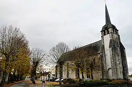 Church of Saint-Euverte | |
Location of Villeherviers  | |
 Villeherviers  Villeherviers | |
| Coordinates: 47°22′01″N 1°47′56″E | |
| Country | France |
| Region | Centre-Val de Loire |
| Department | Loir-et-Cher |
| Arrondissement | Romorantin-Lanthenay |
| Canton | Romorantin-Lanthenay |
| Intercommunality | Romorantinais et Monestois |
| Government | |
| • Mayor (2020–2026) | Hubert Bessonnier |
| Area 1 | 38.9 km2 (15.0 sq mi) |
| Population | 442 |
| • Density | 11/km2 (29/sq mi) |
| Time zone | UTC+01:00 (CET) |
| • Summer (DST) | UTC+02:00 (CEST) |
| INSEE/Postal code | 41282 /41200 |
| Elevation | 85–112 m (279–367 ft) |
| 1 French Land Register data, which excludes lakes, ponds, glaciers > 1 km2 (0.386 sq mi or 247 acres) and river estuaries. | |
Geography
The Rère flows northwest through the eastern part of the commune, then flows into the Sauldre, which flows southwest through the middle of the commune.
Population
|
|
References
- "Populations légales 2019". The National Institute of Statistics and Economic Studies. 29 December 2021.
| Wikimedia Commons has media related to Villeherviers. |
This article is issued from Wikipedia. The text is licensed under Creative Commons - Attribution - Sharealike. Additional terms may apply for the media files.