Vallo di Nera
Vallo di Nera is a comune (municipality) in the Province of Perugia in the Italian region Umbria, located about 60 km southeast of Perugia.
- Images of Vallo di Nera
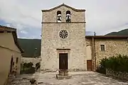 The church San Giovanni Battista
 The church Santa Maria
 The church San Rocco
Vallo di Nera | |
|---|---|
| Comune di Vallo di Nera | |
 | |
 Coat of arms | |
Location of Vallo di Nera  | |
 Vallo di Nera Location of Vallo di Nera in Italy  Vallo di Nera Vallo di Nera (Umbria) | |
| Coordinates: 42°45′N 12°52′E | |
| Country | Italy |
| Region | Umbria |
| Province | Perugia (PG) |
| Frazioni | Borbonea, Geppa, La Pieve, Le Campore, Meggiano, Monte Fiorello, Paterno, Piedilacosta, Piedipaterno, Roccagelli |
| Government | |
| • Mayor | Agnese Benedetti |
| Area | |
| • Total | 36.0 km2 (13.9 sq mi) |
| Elevation | 467 m (1,532 ft) |
| Population (2007)[2] | |
| • Total | 419 |
| • Density | 12/km2 (30/sq mi) |
| Demonym(s) | Vallani |
| Time zone | UTC+1 (CET) |
| • Summer (DST) | UTC+2 (CEST) |
| Postal code | 06040 |
| Dialing code | 0743 |
| Patron saint | St.Giovanni Battista |
| Saint day | 24 June |
| Website | Official website |
| Wikimedia Commons has media related to Vallo di Nera. |
References
- "Superficie di Comuni Province e Regioni italiane al 9 ottobre 2011". Italian National Institute of Statistics. Retrieved 16 March 2019.
- All demographics and other statistics: Italian statistical institute Istat.
This article is issued from Wikipedia. The text is licensed under Creative Commons - Attribution - Sharealike. Additional terms may apply for the media files.