Taihang Mountains
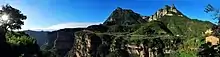
The Taihang Mountains (Chinese: 太行山; pinyin: Tàiháng Shān) are a Chinese mountain range running down the eastern edge of the Loess Plateau in Shanxi, Henan and Hebei provinces. The range extends over 400 kilometres (250 mi)[1] from north to south and has an average elevation of 1,500 to 2,000 metres (4,900 to 6,600 feet). The principal peak is Mount Xiaowutai (2,882 metres (9,455 feet)).[1] The Taihang's eastern peak is Mount Cangyan in Hebei; Baishi Mountain forms its northern tip.
| Taihang Mountains | |
|---|---|
 | |
| Highest point | |
| Peak | Mount Xiaowutai |
| Elevation | 2,882 m (9,455 ft) |
| Dimensions | |
| Length | 400 km (250 mi) |
| Geography | |
 Location in China  Taihang Mountains (China) | |
| Country | China |
| Provinces | Shanxi, Henan and Hebei |
| Range coordinates | 38°N 113°E |

The Taihang Mountains were formed during the Jurassic. Brown forest and cinnamon soils are found here.[2]
The name of Shanxi Province, meaning "west of the mountains", derives from its location west of the Taihang Mountains,[3] as does the name of Shandong Province (east of the mountains).[4]
The Hai River system runs through the Taihang Mountains.[2] The Red Flag Canal is located on the south edge of the Taihang Mountains.
The Shijiazhuang–Taiyuan high-speed railway crosses under the Taihang Mountains via the Taihang Tunnel, which, at almost 28 kilometres (17 mi), is the third longest railway tunnel in China.
See also
References
- "Shanxi | province, China". Encyclopedia Britannica. Retrieved 2021-04-01.
- "Taihang Mountains | mountains, China". Encyclopedia Britannica. Retrieved 2021-04-01.
- "山西省情概况" (in Chinese). Taiwan.cn. 6 April 2011. Retrieved 31 January 2018.
- "山东历史" (in Chinese). sdchina.com. 27 September 2009. Retrieved 31 January 2018.
Many references to this range in “Fanshen” by William Hinton, with their significance in the Chinese Socialist revolution.
External links
| Wikimedia Commons has media related to Taihang Shan Mountains. |
- "A Walk in the Taihang Mountains". Shanghai Star. 2005-03-10. Archived from the original on 2005-03-22. Retrieved 2014-01-30.
Mountain ranges of China | |
|---|---|
| Northwest China | |
| Qinghai-Tibet and Southwest China | |
| Northeast China | |
| North and East China | |
| Central China | |
| South China | |