Shire of Boddington
The Shire of Boddington is a local government area in the Peel region of Western Australia, about 120 kilometres (75 mi) south-east of the state capital, Perth. The Shire covers an area of 1,901 square kilometres (734 sq mi), and its seat of government is the town of Boddington.
| Shire of Boddington Western Australia | |||||||||||||||
|---|---|---|---|---|---|---|---|---|---|---|---|---|---|---|---|
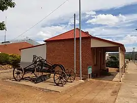 The heritage listed Marradong Road Board Office in Boddington, in use from 1925 to 1965 | |||||||||||||||
 Location in Western Australia | |||||||||||||||
 | |||||||||||||||
| Population | 1,844 (2016 census)[1] | ||||||||||||||
| • Density | 0.97022/km2 (2.5129/sq mi) | ||||||||||||||
| Established | 1892 | ||||||||||||||
| Area | 1,900.6 km2 (733.8 sq mi) | ||||||||||||||
| Shire President | Garry Ventris | ||||||||||||||
| Council seat | Boddington | ||||||||||||||
| Region | Peel | ||||||||||||||
| State electorate(s) | Central Wheatbelt | ||||||||||||||
| Federal division(s) | Canning | ||||||||||||||
| Website | Shire of Boddington | ||||||||||||||
| |||||||||||||||
History
The Mooradung Road District was established on 19 May 1892. It was renamed the Marradong Road District on 30 October 1903.[2]
The board initially convened at Marradong 8 km to the south of Boddington, but relocated to Boddington in 1925 after the arrival of the railway and construction of suitable buildings. On 1 July 1961, the Marradong Road District became the Shire of Boddington following the passage of the Local Government Act 1960, which reformed all remaining road districts into shires.[2]
Wards
The Shire has been divided into 2 wards.
- Town Ward (4 councillors)
- Rural Ward (3 councillors)
Towns and localities
- Bannister (part)
- Boddington
- Crossman
- Lower Hotham
- Marradong
- Mount Wells
- Quindanning
- Ranford
- Upper Murray
- Wuraming
Population
| Year | Population |
|---|---|
| 1921 | 675 |
| 1933 | 918 |
| 1947 | 1,275 |
| 1954 | 1,250 |
| 1961 | 967 |
| 1966 | 761 |
| 1971 | 714 |
| 1976 | 720 |
| 1981 | 778 |
| 1986 | 911 |
| 1991 | 1,416 |
| 1996 | 1,516 |
| 2001 | 1,401 |
| 2006 | 1,379 |
| 2011 | 2,226 |
| 2016 | 1,844 |
Heritage-listed places
As of 2021, 60 places are heritage-listed in the Shire of Boddington,[3] of which one is listed on the State Register of Heritage Places,[4] Asquith Bridge, which was completely destroyed in the bush fire in 2015.[5]
References
- Australian Bureau of Statistics (27 June 2017). "Boddington (S)". 2016 Census QuickStats. Retrieved 1 December 2017.
- "Municipality Boundary Amendments Register" (PDF). Western Australian Electoral Distribution Commission. Retrieved 11 January 2020.
- "Shire of Boddington Heritage Places". inherit.stateheritage.wa.gov.au. Heritage Council of Western Australia. Retrieved 12 March 2021.
- "Shire of Boddington State Register of Heritage Places". inherit.stateheritage.wa.gov.au. Heritage Council of Western Australia. Retrieved 12 March 2021.
- Grace, Millimaci (8 February 2015). "Bushfire claims historic bridge". The West Australian. Retrieved 19 February 2020.