Sayō, Hyōgo
Sayō (佐用町, Sayō-chō) is a town located in Sayō District, Hyōgo Prefecture, Japan.
Sayō
佐用町 | |
|---|---|
Town | |
 Sayo Town Hall | |
 Flag  Chapter | |
 Location of Sayō in Hyōgo Prefecture | |
 Sayō Location in Japan | |
| Coordinates: 35°0′N 134°21′E | |
| Country | Japan |
| Region | Kansai |
| Prefecture | Hyōgo Prefecture |
| District | Sayō |
| Government | |
| • Mayor | Noriaki Anzako |
| Area | |
| • Total | 307.51 km2 (118.73 sq mi) |
| Population (April 30, 2017) | |
| • Total | 17,505 |
| • Density | 57/km2 (150/sq mi) |
| Time zone | UTC+09:00 (JST) |
| Website | www |
| Symbols | |
| Flower | Sunflower |
| Tree | Gingko biloba |
As of April 30, 2017, the town has an estimated population of 17,505.[1] The total area is 307.51 km2.
On October 1, 2005 the towns of Kōzuki, Mikazuki and Nankō, all from Sayō District were merged into Sayō.
History
_aftermath_in_Sayo_21.jpg.webp)
Debris in Sayo after Tropical Storm Etau
In August 2009, around a dozen people in Sayo are dead or missing as a result of flash floods due to Tropical Storm Etau, according to NHK. According to the Japan Times, 390 homes were flooded.
Gallery
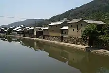 Hirafuku, scenery of the ridge of Sayō River |
References
- "Official website of Sayō Town" (in Japanese). Japan: Sayō Town. Retrieved 13 May 2017.
External links
 Media related to Sayō, Hyōgo at Wikimedia Commons
- Sayō official website (in Japanese)
| Kobe |
| |||
|---|---|---|---|---|
| Core cities | ||||
| Special cities | ||||
| Cities | ||||
| Districts | ||||
This article is issued from Wikipedia. The text is licensed under Creative Commons - Attribution - Sharealike. Additional terms may apply for the media files.