Sancoins
Sancoins (French pronunciation: [sɑ̃kwɛ̃]) is a commune in the Cher department in the Centre-Val de Loire region of France.
Sancoins | |
|---|---|
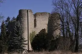 Donjon of Louy castle | |
.svg.png.webp) Coat of arms | |
Location of Sancoins  | |
 Sancoins  Sancoins | |
| Coordinates: 46°49′58″N 2°55′11″E | |
| Country | France |
| Region | Centre-Val de Loire |
| Department | Cher |
| Arrondissement | Saint-Amand-Montrond |
| Canton | Dun-sur-Auron |
| Intercommunality | CC Les Trois Provinces |
| Government | |
| • Mayor (2020–2026) | Pierre Guiblin[1] |
| Area 1 | 53.52 km2 (20.66 sq mi) |
| Population | 2,984 |
| • Density | 56/km2 (140/sq mi) |
| Time zone | UTC+01:00 (CET) |
| • Summer (DST) | UTC+02:00 (CEST) |
| INSEE/Postal code | 18242 /18600 |
| Elevation | 192–233 m (630–764 ft) |
| 1 French Land Register data, which excludes lakes, ponds, glaciers > 1 km2 (0.386 sq mi or 247 acres) and river estuaries. | |
Geography
An area of farming and associated light industry comprising a small town and several hamlets situated by the banks of both the river Aubois and the canal de Berry, about 26 miles (42 km) southeast of Bourges, at the junction of the D2076 with the D951 and D920 roads. The commune shares its southern border with that of the department of Allier.
Population
| Year | Pop. | ±% |
|---|---|---|
| 1990 | 3,634 | — |
| 1999 | 3,562 | −2.0% |
| 2008 | 3,250 | −8.8% |
Sights
- The church of St. Martin, rebuilt in the nineteenth century.
- The fourteenth-century castle of Jouy, built by Pierre de Giac, chancellor of the Duke of Berry.
- Several 15th and sixteenth-century buildings in the main town.
- Javoulet lake.
- The sixteenth-century ‘Joan of Arc’ tower.
Personalities
- Oscar Méténier (1859–1913), writer, was born here.
- Marguerite Audoux (1863–1937), writer, was born here.
See also
References
- "Répertoire national des élus: les maires". data.gouv.fr, Plateforme ouverte des données publiques françaises (in French). 9 August 2021.
- "Populations légales 2019". The National Institute of Statistics and Economic Studies. 29 December 2021.
External links
| Wikimedia Commons has media related to Sancoins. |
- Sancoins website (in French)
- Annuaire Mairie website (in French)
This article is issued from Wikipedia. The text is licensed under Creative Commons - Attribution - Sharealike. Additional terms may apply for the media files.