Rocky Harbour Formation
The Rocky Harbour Formation is a formation cropping out in Newfoundland. Its depositional setting was deltaic, with sediments showing the influence of tides and waves.[2]
| Rocky Harbour Formation | |
|---|---|
Stratigraphic range: | |
| Type | Formation |
| Unit of | Musgravetown Group |
| Lithology | |
| Primary | Marine Sediments |
| Location | |
| Region | |
| Country | |
| Type section | |
| Named by | Jenness 1963 |
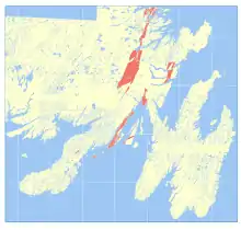 Occurrence of the Rocky Harbour Formation in southeastern Newfoundland[1] | |
Facies from top to bottom
As reported in [3]
- Herring Cove
- Kings Cove Lighthouse
- Purple to pink medium/coarse sandstones with rip-up clasts
- Kings Cove North
- Wave-influenced, light grey/green/yellow fissile siltstone (weathering white); laminated; interbedding with fine ssts.
- Monk Bay
- Dark grey trough-crossbedded and rippled sandstones; poor sorting, coarse to fine grains.
- Cape Bonavista
- Crossbedded coarse pink arkosic sandstones
Type section
Ford's Harbour (previously known (or mapped) as Rocky Harbour).[4]
References
- "Newfoundland & Labrador Geoscience Atlas".
- Normore, L.S. (2012). Geology of the Random Island map area (NTS 2C/04), Newfoundland. Curr. Res. Newfoundl. Labrador Dep. Nat. Resour. Geol. Surv. Report 12-1, 121–145.
- Normore, L.S. (2012). Geology of the Random Island map area (NTS 2C/04), Newfoundland. Curr. Res. Newfoundl. Labrador Dep. Nat. Resour. Geol. Surv. Report 12-1, 121–145.
- Normore, L.S. (2012). Geology of the Random Island map area (NTS 2C/04), Newfoundland. Curr. Res. Newfoundl. Labrador Dep. Nat. Resour. Geol. Surv. Report 12-1, 121–145.
This article is issued from Wikipedia. The text is licensed under Creative Commons - Attribution - Sharealike. Additional terms may apply for the media files.