Musgravetown Group
The Musgravetown Group is a terminal Ediacaran stratigraphic group of terrestrialish sandstones, lavas and tuffs[4] cropping out in Newfoundland.
| Musgravetown Group | ||||
|---|---|---|---|---|
| Stratigraphic range: | ||||
| Type | Group | |||
| Sub-units |
| |||
| Underlies | Bonavista Group (unconformably) | |||
| Overlies | Connecting Point Group | |||
| Location | ||||
| Region | ||||
| Country | ||||
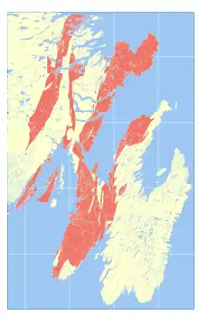 Occurrence of the Musgravetown Group in southeastern Newfoundland | ||||
It corresponds temporally to the Signal Hill Group further east.
References
- Myrow, P (1995). "Neoproterozoic rocks of the Newfoundland Avalon Zone". Precambrian Research. 73 (1–4): 123–136. Bibcode:1995PreR...73..123M. doi:10.1016/0301-9268(94)00074-2.
- Geology compiled by A. F. King Map series edited by S. P. Colman-Sadd and J. P. Hayes, GEOLOGY OF THE AVALON PENINSULA, NEWFOUNDLAND (parts of 1K, 1L, 1M, 1N and 2C) Map 88-01 (Digital reproduction) (PDF)
{{citation}}:|author=has generic name (help) - (PDF) http://www.nr.gov.nl.ca/nr/mines/geoscience/publications/report06_02.pdf.
{{cite journal}}: Cite journal requires|journal=(help); Missing or empty|title=(help) - (PDF) http://www.nr.gov.nl.ca/nr/mines/geoscience/publications/currentresearch/2005/obrien.pdf.
{{cite journal}}: Cite journal requires|journal=(help); Missing or empty|title=(help) - Normore, L.S. (2012). Geology of the Random Island map area (NTS 2C/04), Newfoundland. Curr. Res. Newfoundl. Labrador Dep. Nat. Resour. Geol. Surv. Report 12-, 121–145.
This article is issued from Wikipedia. The text is licensed under Creative Commons - Attribution - Sharealike. Additional terms may apply for the media files.