Rajnagar, Bihar
Rajnagar is the nearest small town to Madhubani, Bihar, India. The ruins of the Rajnagar Palace, destroyed in the 1934 Nepal–Bihar earthquake, are located here.
Rajnagar | |
|---|---|
City | |
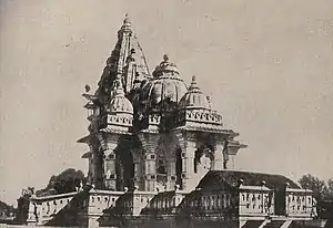 Shiva Temple at Rajnagar before the earthquake, 1934 | |
 Rajnagar Location in Bihar, India  Rajnagar Rajnagar (India) | |
| Coordinates: 26.3958°N 86.1608°E | |
| Country | India |
| State | Bihar |
| Region | Mithila |
| District | Madhubani |
| Government | |
| • Type | Madhubani Municipal Corporation |
| Languages | |
| • Official | Maithili, Hindi, Urdu |
| Time zone | UTC+5:30 (IST) |
| PIN | 847235 |
| ISO 3166 code | IN-BR |
| Website | madhubani |
History
Maharajadhiraj Sir Rameshwar Singh wanted to shift the headquarters of Raj Darbhanga from Darbhanga to Rajnagar and spent money in building palaces and temples and excavating or renovating tanks.[1] The palaces were ruined almost beyond repair and the temples were also very badly damaged.[1] The earthquake rendered the main palace through the Durga hall and the roof over the inner shrines into a mass of ruins and the marble image of the deity broke into pieces.[1]
The Shiva temple built on the South Indian model was beyond repair.[2]
The village has had electricity since 1959. A railway station of the North-Eastern Railway serves the village.[2] The village is also the centre of trade in Euryale ferox (water berries).[2]
Gallery
 Kali Temple at Raj Nagar
 Rajnagar Railway Station is located in Madhubani district
 A Durga temple in the Navlakha palace campus
References
- Chaudhury, P. C. Roy (1964). Bihar District Gazetteers: Darbhanga. Superintendent Secretariat Press, Bihar. p. 738. Retrieved 4 June 2021.
- Chaudhury, P. C. Roy (1964). Bihar District Gazetteers: Darbhanga. Superintendent Secretariat Press, Bihar. p. 739. Retrieved 4 June 2021.