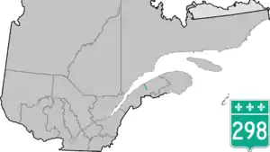
Quebec Route 298
Route 298 is 40 km two-lane north/south highway in Quebec, Canada, which starts in Sainte-Luce at the junction of Route 132 and ends in Saint-Charles-Garnier. Provincial highways with even numbers usually follow the Saint Lawrence River in a somewhat east/west direction, but Route 298 is a north/south highway in almost all of its length.
 | ||||
|---|---|---|---|---|
 | ||||
| Route information | ||||
| Length | 40 km[1] (25 mi) | |||
| Major junctions | ||||
| West end | ||||
| East end | Rue Pineault in Saint-Charles-Garnier | |||
| Location | ||||
| Country | Canada | |||
| Province | Quebec | |||
| Major cities | Sainte-Luce | |||
| Highway system | ||||
| ||||
Municipalities along Route 298
.jpg.webp) Route 298 in Luceville.
Route 298 in Luceville.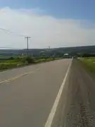 View towards Saint-Donat-de-Rimouski.
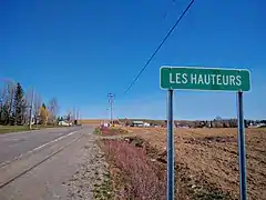 Entering Les Hauteurs-de-Rimouski on Route 298.
 Route 298 climbs hills near Saint-Charles-Garnier.
See also
References
- Ministère des transports, "Distances routières", page (?), Les Publications du Québec, 2005
External links
- Provincial Route Map (Courtesy of the Quebec Ministry of Transportation) (in French)
- Route 298 on Google Maps
This article is issued from Wikipedia. The text is licensed under Creative Commons - Attribution - Sharealike. Additional terms may apply for the media files.