Palamas
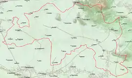
Palamas (Greek: Παλαμάς) is a town and a municipality in the Karditsa regional unit, Greece. Population 16,726 (2011). Palamas is located south-southwest of Larissa, the capital of Thessaly, northwest of Lamia, north of Sofades, east-northeast of Karditsa and east-southeast of Trikala. Palamas is linked with the road linking Karditsa and Larissa. It also serves roads with the GR-6 (Larissa - Trikala - Ioannina - Igoumenitsa) and Sofades. The Pineios River is to the north as well as the Trikala regional unit.
Palamas
Παλαμάς | |
|---|---|
 | |
 Palamas Location within the region  | |
| Coordinates: 39°28′N 22°04′E | |
| Country | Greece |
| Administrative region | Thessaly |
| Regional unit | Karditsa |
| Area | |
| • Municipality | 382.7 km2 (147.8 sq mi) |
| • Municipal unit | 154.1 km2 (59.5 sq mi) |
| Elevation | 105 m (344 ft) |
| Population (2011)[1] | |
| • Municipality | 16,726 |
| • Municipality density | 44/km2 (110/sq mi) |
| • Municipal unit | 8,903 |
| • Municipal unit density | 58/km2 (150/sq mi) |
| Community | |
| • Population | 5,745 (2011) |
| Time zone | UTC+2 (EET) |
| • Summer (DST) | UTC+3 (EEST) |
| Postal code | 432 00 |
| Area code(s) | 26940 |
| Vehicle registration | KA |
Municipality
The municipality Palamas was formed at the 2011 local government reform by the merger of the following 3 former municipalities, that became municipal units:[2]
The municipality has an area of 382.722 km2, the municipal unit 154.077 km2.[3]
Population
| Year | Town | Municipal unit | Municipality |
|---|---|---|---|
| 1981 | 5,448 | - | - |
| 1991 | 6,010 | - | - |
| 2001 | 5,807 | 10,050 | - |
| 2011 | 5,745 | 8,903 | 16,726 |
References
- "Απογραφή Πληθυσμού - Κατοικιών 2011. ΜΟΝΙΜΟΣ Πληθυσμός" (in Greek). Hellenic Statistical Authority.
- "ΦΕΚ B 1292/2010, Kallikratis reform municipalities" (in Greek). Government Gazette.
- "Population & housing census 2001 (incl. area and average elevation)" (PDF) (in Greek). National Statistical Service of Greece.
External links
Administrative division of the Thessaly Region | ||
|---|---|---|
| Regional unit of Karditsa |  | |
| Regional unit of Larissa | ||
| Regional unit of Magnesia | ||
| Regional unit of the Sporades | ||
| Regional unit of Trikala | ||
| ||