Palaikastro
Palaikastro or Palekastro (Greek: Παλαίκαστρο, officially Greek: Παλαίκαστρον), with the Godart and Olivier abbreviation PK, is a thriving town, geographic heir to a long line of settlements extending back into prehistoric times, at the east end of the Mediterranean island Crete. The Kallikratis Programme implemented starting 2011 made the town into a local community (topiki koinoteta) under jurisdiction of the next-highest levels, chained as follows: municipal unit (demotike enoteta) Itanos, municipality (demos) Sitia, regional unit (periphereiakes enotetas) Lasithi, region (periphereia) Crete.[2]
Palaikastro
Παλαίκαστρο | |
|---|---|
 Panorama looking ENE into the Strait of Kasos over the town from some high ground to the west. | |
 Palaikastro | |
| Coordinates: 35°12′N 26°15′E | |
| Country | Greece |
| Administrative region | Crete |
| Regional unit | Lasithi |
| Municipality | Siteia |
| Municipal unit | Itanos |
| Community | |
| • Population | 1,227 (2011) |
| Time zone | UTC+2 (EET) |
| • Summer (DST) | UTC+3 (EEST) |
| Website | Municipal Homepage |
Etymology
At the east edge of the town, visible from a distance, there is a flat hill called Kastri(s). This hill gave Palaikastro its name in the Middle Ages, when Crete was ruled by the Republic of Venice. On its flat summit the Venetians established a fortress. In the course of the centuries the stones were cleared away and used by the people of the region to build houses.
Economy
The main economic activity of the approximately 1100 inhabitants continues to be agriculture. Olives and grape vines are cultivated and a few fishermen remain. Commercial fishing however is difficult these days because of the substantial overfishing in the Mediterranean Sea. Tourism is an important source of supplementary income and is likely to remain so.
Historical significance
It is a historic site. Already in Minoan times the region was a centre of trade. The port of Itanos, today several meters below sea level, is mentioned in ancient times. The very extensive Minoan commercial settlement Roussolakkos close to the Chiona beach, excavated by English archaeologists, clearly shows that the region was one of the most important commercial centres of the Minoan culture in the extreme east of the island of Crete. The Minoan Moulds of Palaikastro were discovered in October 1899 by a farmer 150 metres (160 yd) northeast of the town of Palaikastro. The Palaikastro Kouros is a carved figure of a youth that was recovered in fragments between 1987 and 1990.[3]
Mount Petsofas above the town has the ruins of a Minoan peak sanctuary.
Administrative substructure
The local community of Palaikastro comprises several settlements (oikismoi).
| Name[4] | Greek[5] | Location[6] | Description |
|---|---|---|---|
| Agathia or Angathia | Αγκάθια[7] | 35°11′46″N 26°15′51″E | Commercial village E of P. |
| Chiona | Χιώνα[8] | 35°11′52″N 26°16′37″E | Chiona Beach N of Cape Plaka. Roussolakkos is located there, site of the ancient Minoan city forced inland to P. over the centuries. |
| Chochlakies | Χοχλακιές[9] | 35°08′50″N 26°14′48″E | Village to the W of Chochlakies Gorge S of Cape Plaka |
| Kouremenos | Κουρεμένος | 35°12′43″N 26°16′00″E | Kouremenos Beach is located to the NE of P. up to and including Tenda Point. |
| Kyriamadi | Κυριαμάδι | 35°17′51″N 26°18′09″E | So structured as to make Kyriamadi Forward Naval Base a separate settlement, though not under local jurisdiction. |
| Lydia | Λύδια | 35°11′36″N 26°14′03″E | One villa to the W of P. |
| Mertydia | Μερτύδια | 35°11′43″N 26°14′20″E | Rural area W of the town. |
| Palaikastro | Παλαίκαστρον | 35°11′57″N 26°15′16″E | The center of town itself without the other settlements. |
| Toplou | Τοπλού | So structured as to make Toplou Monastery and the lands on which it sits a separate settlement. The monastery owns lands elsewhere as well. | |
| Vigla | Βίγλα |
Gallery
 Main street
 The church
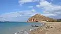 Kastri Hill
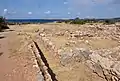 The Minoan site of Roussolakkos
Notes
- "Απογραφή Πληθυσμού - Κατοικιών 2011. ΜΟΝΙΜΟΣ Πληθυσμός" (in Greek). Hellenic Statistical Authority.
- "Palekastro". buk.gr. Retrieved 7 February 2022.
- "The Palaikastro Kouros". Archived from the original on 16 March 2011. Retrieved 14 November 2010.
- Transliteration of the Greek name typically given in Internet translations of Greek texts. The name as used in the texts refers to an administrative area such that the sum of all areas is the area of Itanos. The name may also refer to a known smaller feature, which may be linked to another article.
- The name is the one used by standard Greek-language Internet encyclopedias such as buk.gr, hellenecaworld.com, the .gov.gr sites, or others, such as worldcitydb.com, etc. These are noted with simple links. Translations if desired can usually be obtained from applications such as Google Translate.
- A set of representative coordinates from the area referenced by the name.
- buk.gr
- buk.gr
- buk.gr
References
- Ian Swindale. "Palaikastro". Retrieved 4 February 2006.
External links
| Wikimedia Commons has media related to Palaikastro. |