Niger State
Niger is a state in the North Central region of Nigeria and the largest state in the country. Niger state has three political zones, zone A,B and C. The state's capital is at Minna. Other major cities are Bida, Kontagora and Suleja.[4][5] It was formed in 1976 when the then North-Western State was divided into Niger State and Sokoto State.[4] It is home to Ibrahim Babangida and Abdulsalami Abubakar, two of Nigeria's former military rulers. The Nupe, Gbagyi, Kamuku, Kambari, Gungawa, Hun-Saare, Hausa and Koro form the majority of numerous indigenous tribes of Niger State.[6]
Niger | |
|---|---|
From top, left to right: Minna City gate (exit); Tunga roundabout; AP roundabout; Minna central mosque; St. Michael's Cathedral; Landscape view of Minna city; | |
 Flag | |
| Nickname(s): | |
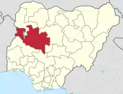 Location of Niger State in Nigeria | |
| Coordinates: 10°00′N 6°00′E | |
| Country | |
| Date created | 3 February 1976 |
| Capital | Minna |
| Government | |
| • Body | Government of Niger State |
| • Governor (List) | Abubakar Sani Bello (APC) |
| • Deputy Governor | Ahmed Muhammad Ketso (APC) |
| • Legislature | Niger State House of Assembly |
| • Senators | E: Sani Musa (APC) N: Aliyu Sabi Abdullahi (APC) S: Muhammad Bima Enagi (APC) |
| • Representatives | List |
| Area | |
| • Total | 76,363 km2 (29,484 sq mi) |
| • Rank | 1st of 36 |
| Population (2006)[1] | |
| • Total | 3,954,772 |
| • Rank | 18th of 36 |
| • Density | 52/km2 (130/sq mi) |
| GDP (PPP) | |
| • Year | 2007 |
| • Total | $6.00 billion[2] |
| • Per capita | $1,480[2] |
| Time zone | UTC+01 (WAT) |
| postal code | 920001 |
| ISO 3166 code | NG-NI |
| HDI (2018) | 0.482[3] low · 28th of 37 |
| Website | nigerstate.gov.ng |


The state is named after the River Niger. Two of Nigeria's major hydroelectric power stations, the Kainji Dam and Shiroro Dam, are located in Niger State, along with the new Zungeru Dam. The Jebba Dam straddles the border of Niger state and Kwara state. The famous Gurara Falls is in Niger State, and Gurara Local Government Area is named after the Gurara River, on whose course the fall is situated.[7] Also situated there is Kainji National Park, the largest National Park of Nigeria, which contains Kainji Lake, the Borgu Game Reserve and the Zugurma Game Reserve.[8]
Government
Like the majority of Nigerian states, it is governed by a Governor and a state House of Assembly. Under the current administration of Abubakar Sani Bello. The state has 25 local government each headed by local government chairman which are also divided into districts, each again with its district head while Villages are headed by village head throughout the state.[5]
See also
Education
Tertiary educational institutions in Niger state include:
Languages
Languages of Niger State listed by LGA:[12]
| LGA | Languages |
|---|---|
| Agaie | Nupe; Dibo; Kakanda; |
| Agwara | Cishingini |
| Bida | Nupe; Hausa; BassaNge; Gbari |
| Borgu | Busa; Bisã; Boko; Cishingini; Laru; Reshe |
| Chanchaga | Basa-Gumna; Basa-Gurmana; Gbagyi; Gbari; Nupe; Kamuku; Tanjijili |
| Edati | Nupe; BassaNge |
| Gbako | Nupe |
| Gurara | Gwandara; Gbagyi |
| Katcha | Nupe; Dibo; Kupa |
| Kontagora | Hausa; Acipa; Eastern; Asu; Tsishingini; Tsuvadi |
| Lapai | Nupe; Dibo; Gbari; Gupa-Abawa; Kakanda; Kami; |
| Magama | Lopa; Tsikimba; Tsishingini; Tsuvadi |
| Mariga | Baangi; Bassa-Kontagora; Cicipu; Kamuku; Nupe; Rogo; Shama-Sambuga; Tsikimba; Tsishingini; Tsuvadi |
| Mashegu | Asu; Tsikimba; Tsishingini; Nupe-Tako |
| Minna | Nupe; Hausa; Gbari; Gbagyi |
| Mokwa | Nupe; Hausa; Yoruba; Gbari |
| Munya | Adara |
| Paikoro | Gbari; Kadara |
| Rafi | Basa-Gurmana; Bauchi; Cahungwarya; Fungwa; Gbagyi; Gbari; Kamuku; Pangu; Rogo; Shama-Sambuga |
| Rijau | Fulani; C'Lela; Tsishingini; Tsuvadi; ut-Hun |
| Shiroro | Gbagyi; Hausa; Gurmana |
| Suleja | Hausa; Gbagyi; Gbari; Gwandara; Nupe; Tanjijili |
| Wushishi | Hausa; Nupe; Gbari |
Sorko and Zarma are also spoken.[12]
Gallery
 Niger state secretariat
 Mobil Junction
 Bahago Roundabout
 St. Michael Catholic Cathedral Minna
 Welcome to Minna
References
- "2006 PHC Priority Tables – NATIONAL POPULATION COMMISSION". population.gov.ng. Archived from the original on 10 October 2017. Retrieved 10 October 2017.
- "C-GIDD (Canback Global Income Distribution Database)". Canback Dangel. Retrieved 20 August 2008.
- "Sub-national HDI – Area Database – Global Data Lab". hdi.globaldatalab.org. Retrieved 13 September 2018.
- Terhemba wuam, Muhammed Lawal Salahu (2014). Aspects of Niger state History: Essays in Honour of Professor Ibrahim Adamu Kolo.
- A.B. Mamman, J.O. Oyebanji (2000). Nigeria: A people United, A Future Assured. Vol.2.
- Baba, J.M (1993). Niger state: Nigeria: Giant in the tropics, Vol.2: state survey.
- Niger state (1999). Niger state official diary, Ministry of Information. Minna.
- "Kainji Lake National Park". United Nations Environment Programme: World Conservation Monitoring Centre. Archived from the original on 30 September 2007. Retrieved 21 October 2010.
- keetu (19 August 2017). "List of Accredited Courses Offered in Federal Polytechnic Bida (Fed Poly Bida)". Retrieved 6 August 2021.
- "Updated List of Courses Offered In FUTMINNA forJAMB 2021 Registration". O3schools. 5 March 2021. Retrieved 6 August 2021.
- keetu (15 September 2018). "List of Accredited Courses Offered in Poly Zungeru (Niger State Polytechnic Zungeru)". Retrieved 6 August 2021.
- "Nigeria". Ethnologue (22 ed.). Retrieved 10 January 2020.
External links
![]() Media related to Niger State at Wikimedia Commons
Media related to Niger State at Wikimedia Commons