Meru District
Meru District Council is one of the seven districts councils of the Arusha Region of Tanzania. Meru District council is bordered to the north by Longido District, to the east by Kilimanjaro Region, to the south by Manyara Region, and to the west by Arusha Rural District and Arusha Urban District. The administrative capital of the council is Usa River.
Meru District Council
Halmashauri ya Meru (Swahili) | |
|---|---|
| Nickname(s): Land of crater lakes | |
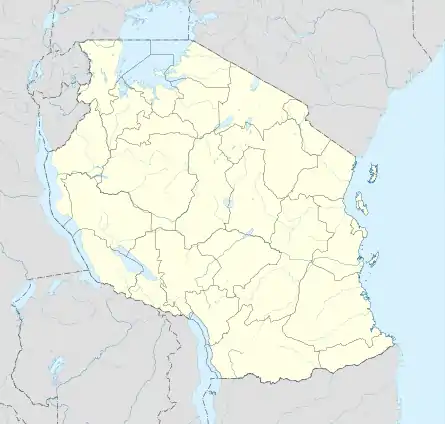
 Meru District's council location within Arusha Region | |
 Meru District Council | |
| Coordinates: | |
| Country | |
| Region | Arusha Region |
| Named for | Meru people |
| Capital | Usa River |
| Area | |
| • Total | 1,266 km2 (489 sq mi) |
| Population (2012) | |
| • Total | 268,144 |
| • Density | 210/km2 (550/sq mi) |
| Demonym(s) | Meruan |
According to the 2012 Tanzania National Census, the population of Meru District council was 268,144.[1]
Etymology
The "Meru" district is named after Mount Meru, which is named after the Meru People.
History
First Communities
The first communities in what would be Meru District were the now extinct Koningo people, hunter gather group that lived around the slopes of Mount Meru for centuries. The second community to settle in the area is the Meru People, whom immigrated there from the Usambara Mountains in Tanga Region.[2] They settled on the southeastern slopes of the mountain and started to farm the land.
Administrative subdivisions
References
- "2012 Population and Housing Census" (PDF). Development Partners Group Tanzania. Retrieved 7 August 2019.
- "Meru and Machame Migrations to Arusha Region". Retrieved 17 October 2021.
{{cite web}}: CS1 maint: url-status (link) - "Arusha Region Roads Network" (PDF). TanRoads. Retrieved 20 August 2019.