Martailly-lès-Brancion
Martailly-lès-Brancion is a commune in the Saône-et-Loire department in the region of Bourgogne-Franche-Comté in eastern France.
Martailly-lès-Brancion | |
|---|---|
 The church in Martailly-lès-Brancion | |
.svg.png.webp) Coat of arms | |
Location of Martailly-lès-Brancion  | |
 Martailly-lès-Brancion  Martailly-lès-Brancion | |
| Coordinates: 46°31′59″N 4°48′11″E | |
| Country | France |
| Region | Bourgogne-Franche-Comté |
| Department | Saône-et-Loire |
| Arrondissement | Mâcon |
| Canton | Tournus |
| Area 1 | 8.85 km2 (3.42 sq mi) |
| Population | 143 |
| • Density | 16/km2 (42/sq mi) |
| Time zone | UTC+01:00 (CET) |
| • Summer (DST) | UTC+02:00 (CEST) |
| INSEE/Postal code | 71284 /71700 |
| Elevation | 214–476 m (702–1,562 ft) (avg. 250 m or 820 ft) |
| 1 French Land Register data, which excludes lakes, ponds, glaciers > 1 km2 (0.386 sq mi or 247 acres) and river estuaries. | |
Gallery
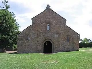
Saint-Peter of Brancion church, built during the 12th century. 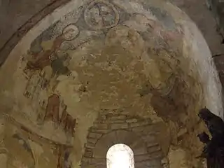
Église Saint-Pierre de Brancion.
Murals from the Middle Ages in the Saint-Peter of Brancion church.
Memorial to the French Resistance and maquis during the Second World War.
References
- "Populations légales 2019". The National Institute of Statistics and Economic Studies. 29 December 2021.
| Wikimedia Commons has media related to Martailly-lès-Brancion. |
This article is issued from Wikipedia. The text is licensed under Creative Commons - Attribution - Sharealike. Additional terms may apply for the media files.