Itxassou
Itxassou (French pronunciation: [itsasu];[3] Basque Itsasu) is a village in the traditional Basque province of Labourd, now a commune in the Pyrénées-Atlantiques department in south-western France.
Itxassou
| |
|---|---|
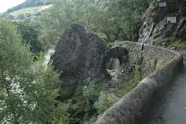 The Pas-de-Roland, alongside the Nive | |
.svg.png.webp) Coat of arms | |
Location of Itxassou  | |
 Itxassou  Itxassou | |
| Coordinates: 43°19′50″N 1°24′15″W | |
| Country | France |
| Region | Nouvelle-Aquitaine |
| Department | Pyrénées-Atlantiques |
| Arrondissement | Bayonne |
| Canton | Baïgura et Mondarrain |
| Intercommunality | CA Pays Basque |
| Government | |
| • Mayor (2020–2026) | Michel Hiribarren[1] |
| Area 1 | 39.37 km2 (15.20 sq mi) |
| Population | 2,168 |
| • Density | 55/km2 (140/sq mi) |
| Time zone | UTC+01:00 (CET) |
| • Summer (DST) | UTC+02:00 (CEST) |
| INSEE/Postal code | 64279 /64250 |
| Elevation | 31–924 m (102–3,031 ft) (avg. 39 m or 128 ft) |
| 1 French Land Register data, which excludes lakes, ponds, glaciers > 1 km2 (0.386 sq mi or 247 acres) and river estuaries. | |
References
- "Répertoire national des élus: les maires". data.gouv.fr, Plateforme ouverte des données publiques françaises (in French). 9 August 2021.
- "Populations légales 2019". The National Institute of Statistics and Economic Studies. 29 December 2021.
- Météo à la carte. "Les cerises d'Itxassou, l'or noir et rare du Pays basque ! - Météo à la carte".
External links
| Wikimedia Commons has media related to Itxassou. |
Municipalities in Labourd (Lapurdi) | ||
|---|---|---|
|  | |
This article is issued from Wikipedia. The text is licensed under Creative Commons - Attribution - Sharealike. Additional terms may apply for the media files.