Heers
Heers (Dutch pronunciation: [ˈɦeːrs] (![]() listen), Limburgish: Hiër [ˈɦiəʀ]) is a municipality located in the Belgian province of Limburg. Since 1971 it comprises the parishes Batsheers, Opheers, Veulen, Gutschoven and Mettekoven, and since 1977 also Mechelen-Bovelingen, Rukkelingen-Loon (which in 1971 had formed Bovelingen), Heks, Horpmaal, Vechmaal (which in 1971 had formed Heks), and Klein-Gelmen (which between 1971 and 1977 had been part of Gelmen, during those years a separate municipality of which the other parishes now belong to the municipality of Sint-Truiden).
listen), Limburgish: Hiër [ˈɦiəʀ]) is a municipality located in the Belgian province of Limburg. Since 1971 it comprises the parishes Batsheers, Opheers, Veulen, Gutschoven and Mettekoven, and since 1977 also Mechelen-Bovelingen, Rukkelingen-Loon (which in 1971 had formed Bovelingen), Heks, Horpmaal, Vechmaal (which in 1971 had formed Heks), and Klein-Gelmen (which between 1971 and 1977 had been part of Gelmen, during those years a separate municipality of which the other parishes now belong to the municipality of Sint-Truiden).

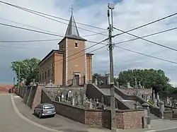
Horpmaal, church: de Sint Lambertuskerk
Heers | |
|---|---|
 Vechmaal: Sint Martinus church | |
 Flag  Coat of arms | |
 Heers Location in Belgium
Location of Heers in Limburg 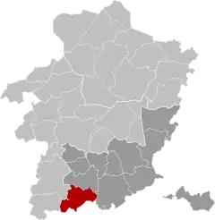 | |
| Coordinates: 50°45′N 05°17′E | |
| Country | Belgium |
| Community | Flemish Community |
| Region | Flemish Region |
| Province | Limburg |
| Arrondissement | Tongeren |
| Government | |
| • Mayor | Henri Dumont (VLDumont) |
| • Governing party/ies | VLDumont |
| Area | |
| • Total | 53.07 km2 (20.49 sq mi) |
| Population (2018-01-01)[1] | |
| • Total | 7,290 |
| • Density | 140/km2 (360/sq mi) |
| Postal codes | 3870 |
| Area codes | 011 |
| Website | www.heers.be |
References
- "Wettelijke Bevolking per gemeente op 1 januari 2018". Statbel. Retrieved 9 March 2019.
External links
 Media related to Heers at Wikimedia Commons
- Site (personal) on Heers – Description of and historical information about each of the parishes of Heers (in Dutch)

This article is issued from Wikipedia. The text is licensed under Creative Commons - Attribution - Sharealike. Additional terms may apply for the media files.