Gometz-le-Châtel
Gometz-le-Châtel (French pronunciation: [ɡɔmɛs lə ʃɑtɛl] (![]() listen)) is a commune in the Essonne department of France. It is a southern suburb of Paris, 25 km from the center of Paris.
listen)) is a commune in the Essonne department of France. It is a southern suburb of Paris, 25 km from the center of Paris.
Gometz-le-Châtel | |
|---|---|
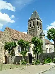 The church of Saint-Clair, in Gometz-le-Châtel | |
.svg.png.webp) Coat of arms | |
Location of Gometz-le-Châtel  | |
 Gometz-le-Châtel  Gometz-le-Châtel | |
| Coordinates: 48°40′41″N 2°08′16″E | |
| Country | France |
| Region | Île-de-France |
| Department | Essonne |
| Arrondissement | Palaiseau |
| Canton | Les Ulis |
| Intercommunality | CA Paris-Saclay |
| Government | |
| • Mayor (2020–2026) | Lucie Sellem[1] |
| Area 1 | 5.06 km2 (1.95 sq mi) |
| Population | 2,664 |
| • Density | 530/km2 (1,400/sq mi) |
| Time zone | UTC+01:00 (CET) |
| • Summer (DST) | UTC+02:00 (CEST) |
| INSEE/Postal code | 91275 /91940 |
| Elevation | 83–169 m (272–554 ft) |
| 1 French Land Register data, which excludes lakes, ponds, glaciers > 1 km2 (0.386 sq mi or 247 acres) and river estuaries. | |
Geography
This village is near Les Ulis, Bures-sur-Yvette, Gif-sur-Yvette and Gometz-la-Ville, along the old road from Paris to Chartres, crossing the Hurepoix.
History
- This is a very old village, known since 1068.
- A train line was built between Paris to Chartres via Gallardon, at the beginning of the 20th century, with a station at Gometz-le-Châtel. It was used from 1931 to 1939, but there is no traffic nowadays. Paris RER, B line, can be used to go there by train Bures-sur-Yvette (Paris RER) or La Hacquinière (Paris RER).
- An experimental Aérotrain was built, from Gometz-le-Châtel to Limours, for a trial, from 1966 to 1977, a creation of Jean Bertin (railway engineer). This experiment was replaced by the TGV, operating currently.
Inhabitants of Gometz le Châtel are called Castelgometziens.
Places to see
- Saint-Clair's Church built during the 10th Century.
- Viaduc des Fauvette
- La Fontaine Miraculeuse
Personalities
- Charles Peguy (French author) lived here for a time.
See also
References
- "Répertoire national des élus: les maires". data.gouv.fr, Plateforme ouverte des données publiques françaises (in French). 2 December 2020.
- "Populations légales 2019". The National Institute of Statistics and Economic Studies. 29 December 2021.
External links
| Wikimedia Commons has media related to Gometz-le-Châtel. |
*Official website (in French)
- Base Mérimée: Search for heritage in the commune, Ministère français de la Culture. (in French)
- Mayors of Essonne Association (in French)
This article is issued from Wikipedia. The text is licensed under Creative Commons - Attribution - Sharealike. Additional terms may apply for the media files.