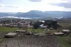
Gerger
Gerger (Kurdish: Aldûş,[5] Armenian: Կարկառ, romanized: Karkaṙ) is a town and a district of Adıyaman Province of Turkey. The mayor is Zeynal Aslan (SP).
Gerger | |
|---|---|
 Gerger | |
 Gerger | |
| Coordinates: 38°01′44″N 39°01′56″E | |
| Country | Turkey |
| Province | Adıyaman |
| Government | |
| • Mayor | Erkan Aksoy[1] (SP) |
| • Kaymakam | Emin Kayman[2] |
| Area | |
| • District | 702.43 km2 (271.21 sq mi) |
| Population (2012)[4] | |
| • Urban | 3,165 |
| • District | 22,526 |
| • District density | 32/km2 (83/sq mi) |
| Post code | 02700 |
| Website | www.gerger.bel.tr |
History
According to The Geographical Journal in 1896, Gerger had 750 inhabitants with most being Kurds, with the exception of few Ottoman officials and Armenians.[6]
In 2018, archaeologists discovered a cave which used during religious ceremonies by Christians during the Byzantine period. Cross figures found inside the cave.[7]
Population
| Year | Total | Districts | Village |
|---|---|---|---|
| 2010 | 24.622 | 3.235 | 21.387 |
| 2009 | 25.440 | 3.242 | 22.198 |
| 2008 | 25.769 | 3.472 | 22.297 |
| 2007 | 25.811 | 4.059 | 21.752 |
| 2000 | 27.208 | 4.223 | 22.985 |
| 1990 | 32.587 | 3.854 | 28.733 |
| 1985 | 32.618 | 4.221 | 28.397 |
| 1980 | 30.380 | 3.704 | 26.676 |
| 1975 | 30.820 | 2.773 | 28.047 |
| 1970 | 29.395 | 2.279 | 27.116 |
| 1965 | 26.723 | 1.229 | 25.494 |
References
- "Belediye Sitesi". gerger.bel.tr (in Turkish). August 4, 2020. Retrieved February 9, 2022.
- "Governer Emin Kaymak". translate.goog. Retrieved February 9, 2022.
- "Area of regions (including lakes), km²". Regional Statistics Database. Turkish Statistical Institute. 2002. Retrieved 2013-03-05.
- "Population of province/district centers and towns/villages by districts - 2012". Address Based Population Registration System (ABPRS) Database. Turkish Statistical Institute. Retrieved 2013-02-27.
- Adem Avcıkıran (2009). Kürtçe Anamnez Anamneza bi Kurmancî (PDF) (in Turkish and Kurdish). p. 56. Retrieved 17 December 2019.
- The Geographical Journal. Royal Geographical Society. 1896.
- Roman-era cave found in Adıyaman
Gerger in Adıyaman Province of Turkey | |||||||||||||||||||||||||||
|---|---|---|---|---|---|---|---|---|---|---|---|---|---|---|---|---|---|---|---|---|---|---|---|---|---|---|---|
| Districts |  Districts of Adıyaman | ||||||||||||||||||||||||||
| |||||||||||||||||||||||||||
Metropolitan municipalities are bolded. | |||||||||||||||||||||||||||
This article is issued from Wikipedia. The text is licensed under Creative Commons - Attribution - Sharealike. Additional terms may apply for the media files.