Gemmano
Gemmano (Romagnol: Zman) is a comune (municipality) in the Province of Rimini in the Italian region Emilia-Romagna, located about 120 kilometres (75 mi) southeast of Bologna and about 15 km (9 mi) south of Rimini.
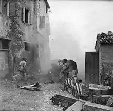
Shelling of German-held Gemmano in September 1944
Gemmano | |
|---|---|
| Comune di Gemmano | |
 | |
 Coat of arms | |
Location of Gemmano  | |
 Gemmano Location of Gemmano in Italy  Gemmano Gemmano (Emilia-Romagna) | |
| Coordinates: 43°54′N 12°35′E | |
| Country | Italy |
| Region | Emilia-Romagna |
| Province | Rimini (RN) |
| Frazioni | Onferno, Zollara, Marazzano, Farneto, Villa. |
| Government | |
| • Mayor | Santi Riziero |
| Area | |
| • Total | 18.85 km2 (7.28 sq mi) |
| Elevation | 404 m (1,325 ft) |
| Population (31 October 2020)[2] | |
| • Total | 1,123 |
| • Density | 60/km2 (150/sq mi) |
| Demonym(s) | Gemmanesi |
| Time zone | UTC+1 (CET) |
| • Summer (DST) | UTC+2 (CEST) |
| Postal code | 47040 |
| Dialing code | 0541 |
| Patron saint | St. Sebastian |
| Saint day | 20 January |
| Website | Official website |
Gemmano borders the following municipalities: Mercatino Conca, Monte Colombo, Montefiore Conca, Montescudo, San Clemente, Sassocorvaro Auditore, Sassofeltrio.
Sights include the sanctuary of Madonna di Carbognano, built on the ancient site of a God Pan temple.
References
- "Superficie di Comuni Province e Regioni italiane al 9 ottobre 2011". Italian National Institute of Statistics. Retrieved 16 March 2019.
- All demographics and other statistics: Italian statistical institute Istat.
This article is issued from Wikipedia. The text is licensed under Creative Commons - Attribution - Sharealike. Additional terms may apply for the media files.