Geesteren, Gelderland
Geesteren is a village in the eastern Netherlands, located in the municipality of Berkelland, Gelderland. It was hit by a small tornado 1988, which lifted the party tent to celebrate the 1000th anniversary of Geesteren and moved it two meters.
Geesteren | |
|---|---|
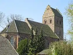 Reformed church | |
 Coat of arms | |
 Geesteren Location in the province of Gelderland  Geesteren Geesteren (Netherlands) | |
| Coordinates: 52°8′20″N 6°31′35″E | |
| Country | Netherlands |
| Province | Gelderland |
| Municipality | Berkelland |
| Area | |
| • Total | 19.68 km2 (7.60 sq mi) |
| Elevation | 15 m (49 ft) |
| Population (2021)[1] | |
| • Total | 1,335 |
| • Density | 68/km2 (180/sq mi) |
| Time zone | UTC+1 (CET) |
| • Summer (DST) | UTC+2 (CEST) |
| Postal code | 7274[1] |
| Dialing code | 0545 |
Geesteren was a separate municipality until 1818, when it was merged with nearby Borculo.[3]
Buildings
Geesteren is well known for its church, which is one of the three churches in Europe with a stepped gable, as a result of this, the tower is topped by two weather cocks instead of just one.
The wind powered grist mill De Ster (The Star) was built in 1859.
Gallery
 Windsmill: molen de Ster
 Sculpture: de Vrouw van 't Starveld
References
- "Kerncijfers wijken en buurten 2021". Central Bureau of Statistics. Retrieved 20 March 2022.
- "Postcodetool for 7274AA". Actueel Hoogtebestand Nederland (in Dutch). Het Waterschapshuis. Retrieved 20 March 2022.
- Ad van der Meer and Onno Boonstra, "Repertorium van Nederlandse gemeenten", KNAW, 2006. "Archived copy". Archived from the original on February 20, 2007. Retrieved December 3, 2009.
{{cite web}}: CS1 maint: archived copy as title (link)
| Wikimedia Commons has media related to Geesteren, Gelderland. |
This article is issued from Wikipedia. The text is licensed under Creative Commons - Attribution - Sharealike. Additional terms may apply for the media files.