Districts of Tajikistan
As of 2020, the regions of Tajikistan are subdivided into 47 districts (Tajik: ноҳия, nohiya or Russian: район, rayon), not including 4 districts belonging to the capital city Dushanbe, and 18 cities of regional subordination (including Dushanbe, an extraregional capital city).[1] Before ca. 2017, there were 58 districts.[2][3][4] The districts are further subdivided into rural municipalities called jamoats, which in turn are further subdivided into villages (or deha or qyshqol).
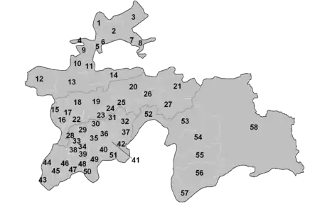
Districts of Tajikistan, situation before 2017
 |
|---|
|
|
|
|
The numbering of the districts follows the map.
Sughd Region
Districts:
| No. | District | Native name | Former names | Capital | Area in km2[5] | Population (2020 estim.)[1] |
|---|---|---|---|---|---|---|
| 1 | Mastchoh | Мастчоҳ | Buston | 1,000 | 128,400 | |
| 2 | Bobojon Ghafurov | Бобоҷон Ғафуров | Leninabad, Khodzhent | Ghafurov | 2,700 | 380,500 |
| 3 | Asht | Ашт | Shaydon | 2,800 | 168,100 | |
| 4 | Zafarobod | Зафаробод | Zafarobod | 400 | 75,900 | |
| 5 | Spitamen | Нов | Nau (until 2003)[6] | Navkat | 400 | 141,600 |
| 6 | Jabbor Rasulov | Ҷаббор Расулов | Proletarsk | Mehrobod | 300 | 137,700 |
| 10 | Shahriston | Шаҳристон | Shahriston | 1,100 | 43,700 | |
| 11 | Devashtich | Ғончӣ | Ghonchi | Ghonchi | 1,600 | 173,500 |
| 13 | Ayni | Айнӣ | Ayni | 5,200 | 83,600 | |
| 14 | Kuhistoni Mastchoh | Кӯҳистони Мастчоҳ | Mehron | 3,700 | 25,400 |
Cities of regional subordination:
| No. | City | Native name | Former names | Area in km2[5] | Population (2020 estim.)[1] |
|---|---|---|---|---|---|
| 7 | Konibodom | Конибодом | 800 | 211,100 | |
| 8 | Isfara | Исфара | 800 | 274,000 | |
| 9 | Istaravshan | Истаравшан | Uroteppa (until 2000) | 700 | 273,500 |
| 12 | Panjakent | Панҷакент | 3,700 | 303,000 | |
| - | Khujand | Хуҷанд | Leninabad | <100 | 183,600 |
| - | Istiqlol | Истиқлол | Taboshar | <100 | 17,900 |
| - | Guliston | Гулистон | Kayrakkum | <100 | 49,200 |
| - | Buston | Бустон | Chkalovsk | <100 | 36,900 |
Areas of Republican Subordination
Districts:
| No. | District | Native name | Former names | Capital | Area in km2[5] | Population (2020 estim.)[1] |
|---|---|---|---|---|---|---|
| 16 | Shahrinav | Шаҳринав | Shahrinav | 1,000 | 123,000 | |
| 18 | Varzob | Варзоб | Varzob | 1,700 | 82,200 | |
| 20 | Rasht | Рашт | Gharm | Gharm | 4,600 | 127,400 |
| 21 | Lakhsh | Лахш | Jirgatol | Vahdat[7] | 4,600 | 66,400 |
| 22 | Rudaki | Рӯдакӣ | Leninskiy (until 2003)[6][8] | Somoniyon | 1,800 | 518,200 |
| 23 | Fayzobod | Файзобод | Fayzobod | 900 | 103,600 | |
| 25 | Nurobod | Дарбанд | Komsomolobod, Darband (until 2003)[9] | Darband | 900 | 82,100 |
| 26 | Tojikobod | Тоҷикобод | Tojikobod | 700 | 46,000 | |
| 27 | Sangvor | Сангвор | Tavildara | Tavildara | 6,000 | 23,300 |
Cities of regional subordination:
| No. | City | Native name | Former names | Area in km2[5] | Population (2020 estim.)[1] |
|---|---|---|---|---|---|
| - | Dushanbe | Душанбе | Stalinabad | 100 | 863,400 |
| 15 | Tursunzoda | Турсунзода | Regar (renamed between 1979 and 1989) | 1,200 | 298,800 |
| 17 | Hisor | Ҳисор | 1,000 | 308,100 | |
| 19 | Vahdat | Ваҳдат | Yangibazar (1927-1936), Ordzhonikidzeabad (1936-1992), Kofarnihon (1992-2003)[10] |
3,700 | 342,700 |
| 24 | Roghun | Роғун | 500 | 44,100 |

Districts of Dushanbe.
Khatlon Region
Districts:
| No. | District | Native name | Former names | Capital | Area in km2[5] | Population (2020 estim.)[1] |
|---|---|---|---|---|---|---|
| 28 | Khuroson | Хуросон | Ghozimalik[11] | Obikiik | 900 | 116,500 |
| 29 | Yovon | Ёвон | Yovon | 900 | 234,600 | |
| 31 | Baljuvon | Балҷувон | Baljuvon | 1,300 | 30,400 | |
| 32 | Khovaling | Ховалинг | Khovaling | 1,700 | 57,900 | |
| 33 | Jomi | Абдураҳмони Ҷомӣ | Kuybyshevsk, Khodzhamaston | Abdurahmoni Jomi | 600 | 175,800 |
| 35 | Danghara | Данғара | Danghara | 2,000 | 161,000 | |
| 36 | Temurmalik | Темурмалик | Qizil-Mazor (until 1957),[12] Sovetskiy (until 2004)[13] |
Sovet | 1,000 | 69,800 |
| 37 | Mu'minobod | Мӯминобод | Leningradskiy | Mu'minobod | 900 | 94,700 |
| 38 | Kushoniyon | Кӯшониён | Bokhtar | Ismoili Somoni | 600 | 245,900 |
| 39 | Vakhsh | Вахш | Vakhsh | 1,000 | 199,300 | |
| 40 | Vose' | Восеъ | Vose' | 800 | 216,500 | |
| 42 | Shamsiddin Shohin | Шамсиддин Шоҳин | Shuroobod | Shuroobod | 2,300 | 55,500 |
| 43 | Nosiri Khusrav | Носири Хусрав | Beshkent[14] | Bahori | 800 | 39,300 |
| 44 | Shahrituz | Шаҳритуз | Shahrituz | 1,500 | 130,000 | |
| 45 | Qubodiyon | Қубодиён | Qubodiyon | 1,800 | 188,100 | |
| 46 | Dusti | Дӯстӣ | Jilikul | Jilikul | 1,200 | 117,100 |
| 47 | Jayhun | Ҷайҳун | Qumsangir | Dusti | 1,000 | 139,000 |
| 48 | Jaloliddin Balkhi | Ҷалолиддин Балхӣ | Kolkhozobod (until 23 June 2007),[15] Rumi | Balkh | 900 | 201,300 |
| 49 | Farkhor | Фархор | Farkhor | 1,200 | 170,800 | |
| 50 | Panj | Панҷ | Panj | 900 | 119,700 | |
| 51 | Hamadoni | Ҳамадони | Moskovskiy | Moskovskiy | 500 | 148,800 |
Cities of regional subordination:
| No. | City | Native name | Former names | Area in km2[5] | Population (2020 estim.)[1] |
|---|---|---|---|---|---|
| - | Bokhtar | Бохтар | Qurghonteppa | <100 | 111,800 |
| 30 | Norak | Норак | 400 | 61,500 | |
| 34 | Levakant | Левакант | Kalininabad, Sarband | 100 | 48,300 |
| 41 | Kulob | Кӯлоб | 300 | 214,700 |
Gorno-Badakhshan Autonomous Region
Districts:
| No. | District | Native name | Former names | Capital | Area in km2[5] | Population (2020 estim.)[1] |
|---|---|---|---|---|---|---|
| 52 | Darvoz | Дарвоз | Qala'i-Khumb | Qal'ai Khumb | 2,800 | 24,000 |
| 53 | Vanj | Ванҷ | Vanj | 4,400 | 34,400 | |
| 54 | Rushon | Рӯшон | Rushon | 5,900 | 25,800 | |
| 55 | Shughnon | Шуғнон | Khorugh | 4,600 | 38,000 | |
| 56 | Roshtqala | Роштқалъа | Roshtqal'a | 4,300 | 27,400 | |
| 57 | Ishkoshim | Ишкошим | Ishkoshim | 3,700 | 32,900 | |
| 58 | Murghob | Мурғоб | Murghob | 37,300 | 15,900 |
City of regional subordination:
| No. | City | Native name | Former names | Area in km2[5] | Population (2020 estim.)[1] |
|---|---|---|---|---|---|
| - | Khorugh | Хоруғ | <100 | 30,500 |
References
- "Population of the Republic of Tajikistan as of 1 January 2020" (PDF) (in Russian). Statistics office of Tajikistan. pp. 13–29. Retrieved 3 October 2020.
- Socio-Economic Atlas of Tajikistan, World Bank (2005)
- Regions of the Republic of Tajikistan 2005, State Committee of Statistics, Dushanbe, 2005 (in Russian)
- Republic of Tajikistan, map showing administrative division as of January 1, 2004, "Tojjikoinot" Cartographic Press, Dushanbe (in Russian)
- "Regions of the Republic of Tajikistan 2017" (PDF) (in Russian). Statistics office of Tajikistan. pp. 15–21. Retrieved 12 October 2020.
- Renaming Nau District to Spitamen District; Leninskiy District to Rudaki District; Frunze District to Sino District; Central District to Firdavsi District
- Presidential News, 4 October 2008 Archived 9 June 2011 at the Wayback Machine
- "Rudaki District". Archived from the original on 2011-09-28. Retrieved 2009-02-12.
- Renaming Darband District to Nurobod District
- "Vahdat District". Archived from the original on 2009-02-01. Retrieved 2009-02-12.
- Ghozimalik District renamed Khuroson District Archived 2011-09-28 at the Wayback Machine (in Russian)
- Qizil-Mazor (Kzyl-Mazar) District renamed Sovetskiy District Archived October 6, 2008, at the Wayback Machine, 1957 (in Russian)
- Sovetskiy District renamed Temurmalik District Archived 2011-09-28 at the Wayback Machine, 2004 (in Russian)
- Beshkent District renamed Nosiri Khusrav District Archived 2011-09-28 at the Wayback Machine, 2004 (in Russian)
- Kolkhozobod District renamed after Jaloliddin Rumi
This article is issued from Wikipedia. The text is licensed under Creative Commons - Attribution - Sharealike. Additional terms may apply for the media files.