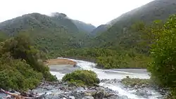
Cropp River
The Cropp River is a river of New Zealand. It flows east for 9 kilometres (6 mi) before joining the Whitcombe River, a tributary of the Hokitika River.[1]
| Cropp River | |
|---|---|
 Cropp River meets the Whitcombe River in the Foreground | |
| Location | |
| Country | New Zealand |
| Physical characteristics | |
| Source | |
| • location | Galena Ridge |
| • elevation | 1,200 m (3,900 ft) |
| Mouth | |
• location | Whitcombe River |
• elevation | 755 m (2,477 ft) |
| Length | 9 km (5.6 mi) |
On 12–13 December 1995, 1,049 millimetres (41.3 in) of rain fell over the Cropp River, at the time that was a record rainfall for a 48-hour period for New Zealand.[2]
On 25–26 March 2019, 1,086 millimetres (42.8 in) of rain fell over the Cropp River, a new record rainfall for a 48-hour period for New Zealand.[3]
The Cropp river area is amongst the top 5 highest, annual, average rainfall areas in the world.[4]
See also
References
- Peter Dowling, ed. (2004). Reed New Zealand Atlas. Reed Books. Map 75. ISBN 0-7900-0952-8.
- "Summary of New Zealand Climate Extremes". NIWA. January 2004. Retrieved 4 September 2009.
- "Weather & climate updates for #NewZealand and worldwide". NIWA. 27 March 2019. Retrieved 27 March 2019.
- "Wettest Places on Earth by Annual Rainfall".
- Land Information New Zealand - Search for Place Names
This article is issued from Wikipedia. The text is licensed under Creative Commons - Attribution - Sharealike. Additional terms may apply for the media files.