Central Region, Uganda
The Buganda region is one of the four regions in the country of Uganda.[1] As of Uganda's 2014 census, the region's population was 9,529,227.[2] It is coterminous with the Kingdom of Buganda, one of the ancient African monarchies that are constitutionally recognised in Uganda.
Buganda | |
|---|---|
 Location of Kampala in Buganda region, Uganda | |
| Coordinates: 00°19′N 032°35′E | |
| Country | Uganda |
| Region | Buganda |
| Regional capital | Kampala |
| Area | |
| • Total | 61,403.2 km2 (23,707.9 sq mi) |
| Elevation | 1,200 m (3,900 ft) |
| Population (2014 census)[2] | |
| • Total | 9,529,227 |
| • Estimate (2011) | 8,465,400 |
| • Density | 160/km2 (400/sq mi) |
| Time zone | UTC+3 (EAT) |
| HDI (2019) | 0.605[3] medium · 1st |
Districts

Kampala Kasubi Tombs
As of 2010, the Central region contains 24 districts:[2]

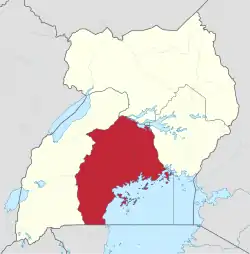
Central region in red.
| District | Population (Census 1991) | Population (Census 2002) | Population (Census 2014) | Map | Chief town |
|---|---|---|---|---|---|
| Buikwe | 250,511 | 329,858 | 422,771 | 82 | Buikwe |
| Bukomansimbi | 126,549 | 139,556 | 151,413 | 84 | Bukomansimbi |
| Butambala | 74,062 | 86,755 | 100,840 | 86 | Gombe |
| Buvuma | 18,482 | 42,483 | 89,890 | 87 | Kitamilo |
| Gomba | 119,550 | 133,264 | 159,922 | 89 | Kanoni |
| Kalangala | 16,371 | 34,766 | 54,293 | 27 | Kalangala |
| Kalungu | 152,028 | 160,684 | 183,232 | 90 | Kalungu |
| Kampala | 774,241 | 1,189,142 | 1,507,080 | 29 | Kampala |
| Kayunga | 236,177 | 294,613 | 368,062 | 36 | Kayunga |
| Kiboga | 98,153 | 108,897 | 148,218 | 38 | Kiboga |
| Kyankwanzi | 43,454 | 120,575 | 214,693 | 95 | Kyankwanzi |
| Luweero | 255,390 | 341,317 | 456,958 | 48 | Luweero |
| Lwengo | 212,554 | 242,252 | 274,953 | 99 | Lwengo |
| Lyantonde | 53,100 | 66,039 | 93,753 | 100 | Lyantonde |
| Masaka | 203,566 | 228,170 | 297,004 | 51 | Masaka |
| Mityana | 223,527 | 266,108 | 328,964 | 56 | Mityana |
| Mpigi | 157,368 | 187,771 | 250,548 | 59 | Mpigi |
| Mubende | 277,449 | 423,422 | 684,337 | 60 | Mubende |
| Mukono | 319,434 | 423,052 | 596,804 | 61 | Mukono |
| Nakaseke | 93,804 | 137,278 | 197,369 | 63 | Nakaseke |
| Nakasongola | 100,497 | 127,064 | 181,799 | 64 | Nakasongola |
| Rakai | 330,401 | 404,326 | 516,309 | 70 | Rakai |
| Sembabule | 144,039 | 180,045 | 252,597 | 72 | Sembabule |
| Wakiso | 562,887 | 907,988 | 1,997,418 | 76 | Wakiso |
Demographics
| Census Year | Population |
|---|---|
| 1991 | 4,843,594 |
| 2002 | 6,575,425 |
| 2014 | 9,529,227 |
References
- "Uganda: Administrative units (source: Uganda Bureau of Statistics)". GeoHive. Retrieved 18 June 2013.
- "Uganda: Administrative Division". citypopulation.de. Retrieved 5 November 2016.
- "Sub-national HDI - Area Database - Global Data Lab". hdi.globaldatalab.org. Retrieved 2018-09-13.
This article is issued from Wikipedia. The text is licensed under Creative Commons - Attribution - Sharealike. Additional terms may apply for the media files.