Caieiras
Caieiras is a municipality in the state of São Paulo in Brazil.[2] It is part of the Metropolitan Region of São Paulo.[3] The population is 102,775 (2020 est.) in an area of 97.64 km².[4] Due to the municipality's large reforestation area, it is known as the "City of the Pines".
Caieiras | |
|---|---|
 | |
 Flag  Coat of arms | |
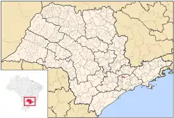
 Location of Caieiras | |
 Caieiras Location of Caieiras | |
| Coordinates: 23°21′52″S 46°44′27″W | |
| Country | |
| Region | Southeast |
| State | |
| Metropolitan Region | São Paulo |
| Government | |
| • Prefect | Gerson Romeiro |
| Area | |
| • Total | 97.64 km2 (37.70 sq mi) |
| Population (2020 [1]) | |
| • Total | 102,775 |
| • Density | 1,100/km2 (2,700/sq mi) |
| Demonym(s) | Caieirense |
| Time zone | UTC-3 (UTC-3) |
| • Summer (DST) | UTC-2 (UTC-2) |
The municipality contains part of the 7,917 hectares (19,560 acres) Cantareira State Park, created in 1962, which protects a large part of the metropolitan São Paulo water supply.[5]
The municipality is served by CPTM Line 7 (Ruby).
Economy
The economy of the city is based on paper industry. Most of the territory of the town consists of reforesting areas belonging to Companhia Melhoramentos de São Paulo.
References
- IBGE 2020
- "Prefeitura Municipal de Caieiras (Portuguese)". Archived from the original on 2011-05-01. Retrieved 2011-01-25.
- "Lei Complementar nº 1.139, de 16 de junho de 2011". Archived from the original on 2015-10-01. Retrieved 2015-09-30.
- "Brazilian Institute of Geography and Statistics" (PDF). 2018. Retrieved 6 March 2019.
2018 Estimates of Population
- Leonel, Cristiane (June 2009), Plano de Manejo do Parque Estadual da Cantareira: Resumo Executivo (PDF) (in Portuguese), SEMA/SP, p. vi, retrieved 2016-12-10
This article is issued from Wikipedia. The text is licensed under Creative Commons - Attribution - Sharealike. Additional terms may apply for the media files.