Béja Governorate
Béja Governorate (Arabic: ولاية باجة Wilāyat Bājah pronounced [ˈbæːʒæ]) is one of the twenty-four governorates of Tunisia. It is in northern Tunisia and has a brief coastline relative to its size. It covers an area of 3,740 km²[1] and had a population of 303,032 as at the 2014 census.[2][3] The capital is Béja and it spans the moderately high Tell Atlas hills and part of the plain between the Tell Atlas and the Dorsal Atlas further south.
Béja
باجة | |
|---|---|
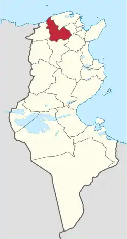 Map of Tunisia with Béja highlighted | |
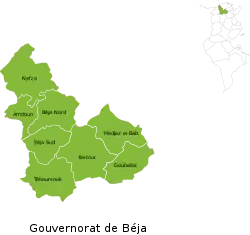 Subdivisions of Béja Governorate | |
| Coordinates: 36°44′N 9°11′E | |
| Country | |
| Created | June 1956[1] |
| Capital | Béja |
| Government | |
| • Governor | Mohsen Moez Mili (since 2019) |
| Area | |
| • Total | 3,740 km2 (1,440 sq mi) |
| • Rank | Ranked 14th of 24 |
| Population (2014) | |
| • Total | 303,032 |
| • Rank | Ranked 18th of 24 |
| • Density | 81/km2 (210/sq mi) |
| Time zone | UTC+01 (CET) |
| Postal prefix | xx |
| ISO 3166 code | TN-31 |
Geography
The governorate is 105 kilometres (65 mi) from the capital and surrounded by the governorates of Bizerte, Zaghouan, Manouba, Siliana, and Jendouba.
The average temperature is 18 °C and annual rainfall is 350-1000 millimeters.[1]
Administrative divisions
Administratively, the governorate is divided into nine delegations (mutamadiyat), eight municipalities, eight rural councils, and 101 sectors (imadas).[1] The delegations and their populations from the 2004 and 2014 censuses,[2] are listed below:
| Delegation | Population in 2004 | Population in 2014 |
|---|---|---|
| Amdoun | 22,484 | 21,187 |
| Béja Nord | 67,471 | 71,198 |
| Béja Sud | 38,396 | 38,101 |
| Goubellat | 16,383 | 15,762 |
| Medjez El Bab | 38,964 | 41,749 |
| Nefza | 53,195 | 48,101 |
| Teboursouk | 24,327 | 22,115 |
| Testour | 32,772 | 33,613 |
| Tibar | 10,509 | 11,206 |
The following eight municipalities are located in Béja Governorate:
| Code | Municipality | Population (2014)[4] |
|---|---|---|
| 2111 | Béja | 62,303 |
| 2112 | El Maâgoula | 7,809 |
| 2113 | Zahret Medien | 5,204 |
| 2114 | Nefza | 7,302 |
| 2115 | Téboursouk | 11,865 |
| 2116 | Testour | 13,331 |
| 2117 | Goubellat | 4,128 |
| 2118 | Majaz al Bab | 21,653 |
References
- (in French) "tunisieindustrie.nat.tn". Archived from the original on 2009-02-17.
- "2014 Tunisian census data". Archived from the original on 2015-05-18.
- (in French) Census 2014 (National Institute of Statistics) Archived 2014-10-29 at the Wayback Machine
- Recensement Général de la Population et de l'Habitat 2014 – Population, logements et ménages par commune et arrondissement [Census 2014 results – population, accommodation and households per municipality and delegation] (Report) (in French). National Institute of Statistics. 1 April 2015. Retrieved 18 February 2016.
Governorates and regions of Tunisia | ||
|---|---|---|
| Governorates | ||
| Regions | ||
WikiProject Tunisia | ||