Touloubre
The Touloubre is a river in the southeast of France. It runs from Venelles to the Étang de Berre.[1] Other places along its course are Pélissanne, Salon-de-Provence, Grans and Saint-Chamas. It flows into the Étang de Berre, which is connected to the Mediterranean Sea, near Saint-Chamas. It is 59.6 km (37.0 mi) long.[2] Its drainage basin is 401 km2 (155 sq mi).[3]
| Touloubre | |
|---|---|
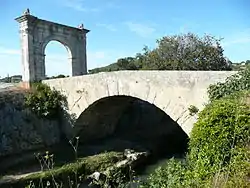 Touloubre passing the Roman Pont Flavien | |
  | |
| Location | |
| Country | France |
| Physical characteristics | |
| Mouth | |
• location | Étang de Berre |
• coordinates | 43°31′22″N 5°2′55″E |
| Length | 59.6 km (37.0 mi) |
| Basin size | 401 km2 (155 sq mi) |
| Basin features | |
| Progression | Étang de Berre→ Mediterranean Sea |
References
- PDF from official website
- Sandre. "Fiche cours d'eau - la touloubre (Y42-0400)".
- Bassin versant : Touloubre (La), Observatoire Régional Eau et Milieux Aquatiques en PACA
This article is issued from Wikipedia. The text is licensed under Creative Commons - Attribution - Sharealike. Additional terms may apply for the media files.