Pico do Areeiro
Pico do Areeiro (often wrongly written as Pico do Arieiro), at 1,818 m (5,965 ft) high, is Madeira Island's third highest peak.[2] From the top, visitors can look down on the clouds on most days. The air is fresh and clear and the sun is very bright. On a clear day it is possible to see the neighboring island of Porto Santo, 48 km (30 mi) to the northeast.
| Pico do Areeiro | |
|---|---|
 View of Pico Do Areeiro from the west | |
| Highest point | |
| Elevation | 1,818 m (5,965 ft)[1] |
| Coordinates | 32°44′08″N 16°55′44″W |
| Geography | |
 Pico do Areeiro Location of Pico do Arieiro in Madeira | |
| Location | Madeira |
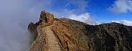
The footpath northwards towards Pico Ruivo is an important tourist attraction, with a daily average of 1000 tourists trekking on it.
There is easy road access to the summit, with a large car park, a restaurant and souvenir shop. In 2011, an Air Defence Radar Station of the Portuguese Air Force was built at the top of the mountain near the tourist facilities.


Climate
Pico do Areeiro has a cool Mediterranean climate, surprisingly wet for this type of climate due to the extreme precipitation it gets, a big part of it from drizzle and fog.
| Climate data for Pico do Areeiro, 1961-1990, 1,610 m (5,280 ft) altitude | |||||||||||||
|---|---|---|---|---|---|---|---|---|---|---|---|---|---|
| Month | Jan | Feb | Mar | Apr | May | Jun | Jul | Aug | Sep | Oct | Nov | Dec | Year |
| Average high °C (°F) | 8.1 (46.6) |
8.4 (47.1) |
9.0 (48.2) |
9.0 (48.2) |
11.4 (52.5) |
14.4 (57.9) |
18.5 (65.3) |
18.8 (65.8) |
16.1 (61.0) |
13.2 (55.8) |
10.4 (50.7) |
8.5 (47.3) |
12.1 (53.9) |
| Daily mean °C (°F) | 5.5 (41.9) |
5.6 (42.1) |
6.2 (43.2) |
6.1 (43.0) |
8.2 (46.8) |
11.0 (51.8) |
14.6 (58.3) |
14.8 (58.6) |
12.8 (55.0) |
10.3 (50.5) |
7.8 (46.0) |
6.0 (42.8) |
9.1 (48.3) |
| Average low °C (°F) | 2.9 (37.2) |
2.8 (37.0) |
3.4 (38.1) |
3.2 (37.8) |
5.0 (41.0) |
7.6 (45.7) |
10.7 (51.3) |
10.8 (51.4) |
9.5 (49.1) |
7.4 (45.3) |
5.2 (41.4) |
3.5 (38.3) |
6.0 (42.8) |
| Record low °C (°F) | −3.0 (26.6) |
−4.3 (24.3) |
−4.3 (24.3) |
−6.0 (21.2) |
−0.9 (30.4) |
1.0 (33.8) |
2.4 (36.3) |
4.3 (39.7) |
3.3 (37.9) |
0.0 (32.0) |
−2.5 (27.5) |
−3.0 (26.6) |
−6.0 (21.2) |
| Average precipitation mm (inches) | 437.0 (17.20) |
371.6 (14.63) |
302.4 (11.91) |
211.3 (8.32) |
116.6 (4.59) |
69.8 (2.75) |
13.2 (0.52) |
33.5 (1.32) |
169.7 (6.68) |
306.8 (12.08) |
448.9 (17.67) |
447.0 (17.60) |
2,927.8 (115.27) |
| Source: [3] | |||||||||||||
References
- Pico do Arieiro at peakbagger.com
- Madeira Geography Archived 2011-07-14 at the Wayback Machine
- Quintal, José Raimundo Gomes. "Estudo fitogeográfico dos jardins, parques e quintas do concelho do Funchal" (PDF). University of Lisbon. Retrieved 11 February 2021.