Maya Mountains
The Maya Mountains are a mountain range located in Belize and eastern Guatemala, in Central America.
| Maya Mountains | |
|---|---|
| Montañas Mayas | |
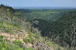 Maya Mountains during clear conditions | |
| Highest point | |
| Peak | Doyle's Delight |
| Elevation | 1,124 m (3,688 ft) |
| Coordinates | 16°29′39″N 89°2′45″W |
| Dimensions | |
| Length | 70 mi (110 km) |
| Geography | |
| Countries | Belize and Guatemala |
| Geology | |
| Age of rock | Mesozoic (Cretaceous) |
| Type of rock | Karstic |
Geography
The range's highest peaks are Doyle's Delight at 1,124 metres (3,688 ft), and Victoria Peak at 1,120 metres (3,670 ft).
Much of the range is in protected areas, including Cockscomb Basin Wildlife Sanctuary, Bladen Nature Reserve, Chiquibul National Park, and the Maya Mountain, Columbia River, and Chiquibul forest reserves in Belize, and Yaxhá-Nakum-Naranjo National Park and San Román Biological Reserve in Guatemala.[1]
History
The mountains are mainly made of Paleozoic era granite and sediments.
The Maya Mountains and associated foothills contain a number of important Mayan ruins including the sites of Lubaantun,[2] Nim Li Punit, Cahal Pech,[3] and Chaa Creek.

See also
- Mountain ranges of Central America
References
- UNEP-WCMC (2022). Protected Area Profile for Belize from the World Database of Protected Areas. Accessed 28 March 2022.
- C.Michael Hogan, Lubaantun, The Megalithic Portal (2007)
- "Distribution of Early Middle Formative Period Sites". Archived from the original on 2003-02-20. Retrieved 2008-03-15.
![]() Media related to Maya Mountains at Wikimedia Commons
Media related to Maya Mountains at Wikimedia Commons