Manzanita Lake
Manzanita Lake is a lake located in Lassen Volcanic National Park. The name means "little apple" in Spanish.
| Manzanita Lake | |
|---|---|
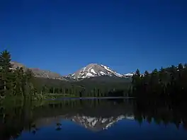 Lassen Peak reflected in Manzanita Lake | |
 Manzanita Lake  Manzanita Lake | |
| Location | Lassen Volcanic National Park, Shasta County, California, US |
| Coordinates | 40.53371°N 121.56780°W |
| Native name | Lago Manzanita (Spanish) |
| Basin countries | United States |
Located near the park entrance, the lake is open for fishing and has rainbow, brown and brook trout.[1]
Manzanita Lake was formed when Manzanita Creek was dammed 300 years ago by a rock avalanche from the northwest slope of the Chaos Crags, which also resulted in the debris formation known as Chaos Jumbles.[2]
The area around the lake features the Loomis Museum, a campground, and the Manzanita Lake Naturalist's Services Historic District.
 View of Chaos Crags and Lassen Peak from the lakeshore.
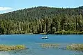 Fishing on Manzanita Lake.
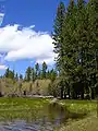 The shore of Manzanita Lake.
Climate
Manzanita Lake has a warm-summer humid continental climate (Dsb) using the 0°C isotherm or a warm-summer mediterranean climate (Csb) using the -3°C isotherm with short, warm summers and cool winters, with most precipitation falling in the winter months.
| Climate data for Manzanita Lake, California (normals 1981-2010)(snowfall 1963-1994)(extremes 1949-2020) | |||||||||||||
|---|---|---|---|---|---|---|---|---|---|---|---|---|---|
| Month | Jan | Feb | Mar | Apr | May | Jun | Jul | Aug | Sep | Oct | Nov | Dec | Year |
| Record high °F (°C) | 77 (25) |
78 (26) |
81 (27) |
88 (31) |
88 (31) |
94 (34) |
97 (36) |
96 (36) |
96 (36) |
88 (31) |
78 (26) |
68 (20) |
97 (36) |
| Average high °F (°C) | 42.4 (5.8) |
43.1 (6.2) |
47.1 (8.4) |
52.2 (11.2) |
61.7 (16.5) |
70.5 (21.4) |
78.8 (26.0) |
78.4 (25.8) |
72.3 (22.4) |
60.8 (16.0) |
47.0 (8.3) |
41.4 (5.2) |
58.0 (14.4) |
| Daily mean °F (°C) | 31.9 (−0.1) |
32.3 (0.2) |
35.8 (2.1) |
40.0 (4.4) |
48.1 (8.9) |
55.6 (13.1) |
62.1 (16.7) |
61.1 (16.2) |
56.0 (13.3) |
47.0 (8.3) |
36.5 (2.5) |
31.5 (−0.3) |
44.8 (7.1) |
| Average low °F (°C) | 21.4 (−5.9) |
21.5 (−5.8) |
24.5 (−4.2) |
27.8 (−2.3) |
34.5 (1.4) |
40.7 (4.8) |
45.3 (7.4) |
43.9 (6.6) |
39.6 (4.2) |
33.2 (0.7) |
26.1 (−3.3) |
21.5 (−5.8) |
31.7 (−0.2) |
| Record low °F (°C) | −13 (−25) |
−11 (−24) |
−7 (−22) |
−2 (−19) |
11 (−12) |
19 (−7) |
26 (−3) |
28 (−2) |
19 (−7) |
10 (−12) |
2 (−17) |
−13 (−25) |
−13 (−25) |
| Average precipitation inches (mm) | 5.91 (150) |
5.23 (133) |
5.10 (130) |
3.72 (94) |
3.19 (81) |
1.30 (33) |
0.45 (11) |
0.39 (9.9) |
1.17 (30) |
3.04 (77) |
5.43 (138) |
6.22 (158) |
41.15 (1,045) |
| Average snowfall inches (cm) | 33.1 (84) |
34.9 (89) |
33.9 (86) |
20.8 (53) |
6.3 (16) |
0.8 (2.0) |
0 (0) |
0 (0) |
0.1 (0.25) |
3.9 (9.9) |
11.8 (30) |
31.7 (81) |
177.3 (450) |
| Source: NOAA[3] | |||||||||||||
See also
References
- "Manzanita Lake". Wild Trout & Catch-and-Release Waters. California Department of Fish and Game. 2003. Retrieved May 12, 2006.
- Hill, Richard L. (2004-10-01). Volcanoes of the Cascades: Their Rise and Their Risks. Falcon. pp. 86–87. ISBN 978-0-7627-3072-8.
- "Manzanita Lake - NWS Sacramento NOAA Online Weather Data". NOAA. Retrieved February 7, 2021.
External links
 Media related to Manzanita Lake at Wikimedia Commons