The Mall, Lahore
Shahrah-e-Quaid-e-Azam (Urdu: شاہراہ قائد اعظم), formerly known as The Mall or Mall Road (Urdu: سڑک مال, Sarak-e-Mall), is a major road in Lahore, Pakistan.[1]
| Shahrah-e-Quaid-e-Azam شاہراہ قائد اعظم | |
|---|---|
| The Mall سڑک مال | |
| Route information | |
| Maintained by City District Government Lahore | |
| Length | 6.5 km (4.0 mi) |
| Existed | 2016–present |
| Major junctions | |
| From | |
| To | Mian Mir Bridge, Aziz Bhatti Road |
| Location | |
| Country | Pakistan |
| Highway system | |
The road was laid out during the British Raj on a route leading to the Governor's House, lined on both sides with Mughal shrines and kilns.[2]
Attractions
Places of historical, cultural and recreational significance on The Mall include:
- Amal Academy
- Aitchison College
- Alhamra Arts Council
- Avari Hotel
- Cathedral Church of Resurrection
- Qurban Lines (Police)
- Bagh-e-Jinnah (formerly Lawrence Gardens)
- Charing Cross
- Diyal Singh Mansion
- Ganga Ram Mansion
- Government College University
- Governor's House
- King Edward Medical College
- Lahore American School
- Lahore Museum
- Lahore Zoo
- Masonic Temple
- National College of Arts
- Pearl Continental Hotel
- Provincial Assembly of the Punjab
- Shah Din Manzil
- State Guest House
- Tollinton Market
- University of the Punjab
- Wapda House
- Zamzama Gun (also known as Kim's Gun)
Gallery
 Masonic Temple
 Lahore Museum
 Government College University
 Sacred Heart Cathedral
 St. Anthony's College
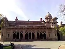 Aitchison College
 Ferozesons Books
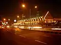 Tollinton Market
 Bird Houses on Mall Road
 Anarkali Stop
References
- Google maps. "Location of Mall Road". Google Maps. Retrieved 24 September 2013.
{{cite web}}:|last=has generic name (help) - Jan Morris and Simon Winchester (2005). Stones of Empire: The Buildings of the Raj. Oxford University Press. pp. 203–205. ISBN 978-0-19-280596-6.
| Wikimedia Commons has media related to The Mall, Lahore. |
This article is issued from Wikipedia. The text is licensed under Creative Commons - Attribution - Sharealike. Additional terms may apply for the media files.