Lemberg (Nahe)
The Lemberg is a hill on the river Nahe between the villages of Niederhausen (Nahe), Oberhausen an der Nahe and Feilbingert. At 422 metres, it is the highest hill on the Nahe.
| Lemberg | |
|---|---|
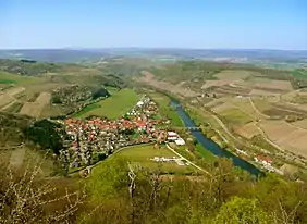 View of the River Nahe from the Lemberg | |
| Highest point | |
| Elevation | 421 m above sea level (NN) (1,381 ft) |
| Coordinates | 49°46′54″N 7°46′04″E |
| Geography | |
 Lemberg | |
Linguistic researchers believe the derivation of the name Lemberg is Lindberg ("lime hill") and local poets call it the "King of the Nahegau" (König des Nahegaus).[1] The magmatic rock, porphyry, which is found here points to its volcanic origin.
References
- "Landesamt für Vermessung und Geobasisinformation Rheinland-Pfalz". lvermgeo.rlp.de. Retrieved 21 Nov 2014.
This article is issued from Wikipedia. The text is licensed under Creative Commons - Attribution - Sharealike. Additional terms may apply for the media files.