Langbaurgh Wapentake
Langbaurgh /lɑːŋɡbɑːrθ/[1] was a liberty or wapentakes of Yorkshire, North Riding. It covered an area of the shire's north-eastern tip. The wapentake took its name from Langbaurgh hamlet, in present day Great Ayton parish.[2]
| Langbaurgh | |
|---|---|
| Wapentake | |
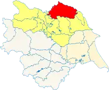 Wapentakes of the North Riding of Yorkshire, in yellow. Langbaurgh is in red. | |
| History | |
| • Type | 41 Parishes |
| Subdivisions | |
| • Type | Western and Eastern |
The name was re-used for the non-metropolitan district of Langbaurgh, later Langbaurgh-on-Tees, created in 1974, which covered the area of the eastern division. It has been known since 1996 as the unitary authority of Redcar and Cleveland.
Extent
The northern extent covering the south of the Tees from Low Worsall to South Gare. The south eastern extent varied: 1068 the area covered three of four parishes (excluding Hackness) of what came to be the Whitby Strand. Dunsley beck later formed the southern coastal boundary with the Whitby Strand wapentake. The south western extent varied around the Tees basin into the Yorkshire Moors.[3][4]
References
- "Langbaurgh Wapentake". Vision of Britain. Retrieved 7 December 2005.
- "Unpronounceable Langbaurgh lives on". Stockton and Darlington Times. Retrieved 13 March 2021.
- William Page, ed. (1923). Parishes: Great Ayton. A History of the County of York North Riding: Volume 2. Victoria County History. pp. 225–231. Retrieved 8 September 2015.
- William Page, ed. (1923). The wapentake of Langbaurgh (west): Introduction. A History of the County of York North Riding: Volume 2. Victoria County History. pp. 217–220. Retrieved 14 January 2021.
- William Page, ed. (1923). The liberty of Whitby Strand. A History of the County of York North Riding: Volume 2. Victoria County History. pp. 502–505. Retrieved 14 January 2021.