Horton, Surrey
Horton is a semi-rural area with a village centre in the west of the borough of Epsom and Ewell in the English county of Surrey. It is situated between Epsom, West Ewell and Chessington. It's principal road is Horton Lane, which runs the length of the area between West Ewell and Epsom Common. Horton covers the west part of the KT19 postcode which comes under part of the Epsom postal area. Horton Country Park also runs along the length of the area, between Epsom Common and West Ewell.
| Horton | |
|---|---|
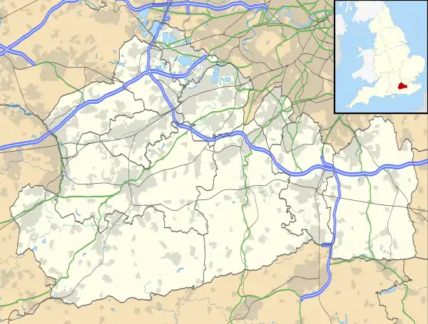 Horton Location within Surrey | |
| Area | 1.5 sq mi (3.9 km2) |
| Population | 5,000 |
| • Density | 3,333/sq mi (1,287/km2) |
| OS grid reference | TQ1962 |
| • London | 12.8 mi (20.6 km) NNE |
| District | |
| Shire county | |
| Region | |
| Country | England |
| Sovereign state | United Kingdom |
| Post town | EPSOM |
| Postcode district | KT19 |
| Dialling code | 01372 |
| Police | Surrey |
| Fire | Surrey |
| Ambulance | South East Coast |
| UK Parliament | |
The place-name Horton is a common one in England. It derives from Old English horu 'dirt' and tūn 'settlement, farm, estate', presumably meaning 'farm on muddy soil'.[1] It gave its name to the Horton Light Railway which served a number of the psychiatric hospitals in the area, collectively known as the Epsom Cluster.
Since the start of the 21st century, Horton has undergone rapid change. The hospitals which made of the Epsom Cluster closed as Care within the community for mental health patients became predominant. Multiple housing estates including Manor Park wereconstructed on the site, in addition to a number of shops in the centre of the area. In 2022, Horton was made a ward of Epsom and Ewell due to the population increase in the area.
History
Early History: Ancient use and the Horton Manor Estate
The earliest evidence of human activity in Horton is from the mid-Bronze Age. Remains of pits, ditches and post holes in Long Grove Road indicate that the Horton area was used for agriculture in prehistoric times, which may suggest the presence of an established settlement nearby.[2] Pottery sherds and worked flints, found on the site of the former Manor Hospital site in Horton, show that human activity continued into the early Iron Age[3] and two staters (coins) from this period have been found in the area.[4]
As shown in an 1805 Ordnance Survey map of the area, Horton was a hamlet, separated by fields from the more substantial settlements of Ewell and Epsom.
During the 19th Century, the Horton Manor Estate existed across what is now present-day Horton. Owned by Thomas Buxton, it contained the hamlet of Horton, where the present day Horton Local Centre is located. A map from 1890 shows Horton Farm existed (now Hobbledown). Horton Manor House was located on what is now the western edge of the Manor Park Estate today. The Horton Manor Estate was part of the Epsom Parish. The north of the estate bordered the Ewell Parish.[5]
20th Century: Epsom Hospital Cluster
By the 1890's, psychiatric instutions in London were overcrowded, so a solution was sought outside of London. In 1896, a large proportion of the Horton Estate was bought for £35000 by London County Council to build new hospitals.[6] The Epsom Cluster was a group of five prodominantly psychiatric hospitals which operated in the locality throughout the 20th Century. They were linked by the Horton Light Railway, which branched off from the primary railway near Ewell West railway station.
Manor Hospital
Constructed from 1896 to 1899, this was the first psychiatric hospitals in the area. It closed in 1996. The area (in the south east of Horton) is now the Manor Park housing estate, backing on to Long Grove Park.
Horton Hospital
Horton Hospital was in the centre of the area, where the local retail centre now stands. It operated between 1902 and 1997, with some use of the site intil 2002. The hospital was a leading malaria research centre in the early 1970's. The Wolvercote Clinic (for the rehabilitation of sex offenders) ran from 1995 to 2002. The hospital land was then sold off by the government for development, which was constructed in the remainder of the 2000's decade.
St Ebba’s Hospital
Formerly the Ewell Epileptic Hospital (1904-18) before catering to patients with learning disabilities in the latter half of the 20th century.
The area, in the east of Horton now contains the Parkviews housing estate, which was completed in 2012. Small parts of the hospital still operate today.
Long Grove Hospital
Operated from 1907 to 1992 in the far west of the area. This psychiatric hospital was used in part for the contatiment of typhoid fever by incarcerating female carriers ofnthe disease. The gangster Ronnie Kray was a patient of the hospital in 1957. After Long Grove was closed, the Clarendon Park housing estate was built on the site of the hospital. It was completed by 2002. Some of the landscaped grounds of the hospital are preserved in Horton Country Park.
West Park Hospital
Operated from 1921 to 2003. A clinic still exists here, although this area is also predominantly a housing estate. Located in the south of Horton and is adjacent to both Horton Country Park and Epsom Common.
Later History: Housing and retail development
Housing estates rapidly sprung up on the former sites of the Epsom Cluster institutions, including Manor Park and Clarendon Park. They are all connected to Horton Lane via the extensive network of roundabouts.
The housing development coincided construction of a local retail centre in the middle of Horton. This was completed around 2010, containing a variety of amenities. Horton was made a ward of Epsom and Ewell Borough Council in 2022 owing to the substantial housing developments in the area. Previously, Horton was split into four different wards.
Geography
Horton is centred on the area of shops near the roundabout of Horton Lane and Chantiliy Way. This shopping parade gives the area a village centre like feel. Horton travells the length of Horton (SSW to NNE) from Epsom Common to Hook Road Arena. The road contains cycle lanes both on the road and pavement, alongside a wide footpath. Hobbledown childrens park is located close to Horton's centre.
Horton Country Park runs along the length of the western side of the area. Newly constructed housing estates can be found on both sides of Horton Lane on the site of former hospitals. Horton Park Golf Course occupies the north-west of the area. A smaller park, Long Grove Park and a primary school is in the east of the area, with the Old Moat Garden Centre in the south.
Localities
Housing Estates
Include Clarendon Park in the north-west, Manor Park in the south-east and West Park in the south-west. Parkviews can be found in the north-east on the site of St Ebba's Hospital.
Horton Local Centre
An area of shops in the middle of the area near to the junction of Horton Lane and Chantiliy Way. Centred around a large car park, its principal shop is the Tesco Express Convenience store. The area opened in 2010. The David Lloyd Leisure Centre and Hobbledown Children's park are located nearby.
Horton Park Golf Club
Contains an 18 hole course, a Par 3 9 hole course, a driving range in addition to a crazy golf course which opened in 2014. Located in the north of Horton, contiguous with Horton Country Park
Hook Road Arena
An area of enclosed green space located in the north of Horton. Hosts funfair events in addition to the annual firework and bonfire night. The Epsom Riding for the Disabled Association (RDA) horse riding charity is based adjacent to the arena.
Horton Country Park
A 1.5 mile long area of open space just west of Horton Lane, with a large car park. A mixture of woodland and fields, containing some horses in the fields. Contains Epsom Polo Club. Adjacent to Epsom Common and Castle Hill Nature Reserve, Chessington.
Hobbledown
An adventure park and zoo, located just west of Horton Lane, adjacent to the David Lloyd Centre and Horton Country Park. Contains a soft play area. Formerly known as Horton Park Children's Farm.
Long Grove Park
An enclosed space located in the east of the area. Contains a playground and is adjacent to the residential area in the west of Epsom. The park is also continous with open space beside Abbots Avenue.
Surrounding Area
The nearest towns to Horton is Epsom and Chessington, located 1.5 miles to the east and west respectively. The residential area of West Ewell is contiguous with Horton.
Surrounding areas of Surrey and London | |
|---|---|
References
- Victor Watts (ed.), The Cambridge Dictionary of English Place-Names, Based on the Collections of the English Place-Name Society (Cambridge: Cambridge University Press, 2004), s.v. HORTON.
- Stevenson, J. (2005). "An archaeological excavation at Long Grove Road, Epsom" (PDF). Surrey Archaeological Collections. 92: 161–170. doi:10.5284/1069347. Archived (PDF) from the original on 5 June 2021. Retrieved 5 June 2021.
- Saunders, M.J. (2000). "Late Bronze/Early Iron Age settlement evidence from Manor Hospital, Epsom" (PDF). Surrey Archaeological Collections. 87: 175–178. doi:10.5284/1069276. Archived (PDF) from the original on 5 June 2021. Retrieved 5 June 2021.
- Pattison, G. (2000). "An Archaeological Watching Brief During the 'Epsom Hositals Cluster' Road Scheme Development, Horton Lane, Epsom". Surrey County Archaeological Unit.
- https://eehe.org.uk/?p=25027 'Epsom Cluster'Epsom and Ewell History Explorer
- "The Horton Estate, Epsom Cluster, Epsom". Retrieved 23 December 2008.
Following the Legislation passed in 1888 the London County Council begun to build the necessary institutions around the London Boroughs. However these became over-crowded very quickly and a solution was needed and in 1896, 1096 acres of the Horton estate in Epsom was acquired for the price of £35,900. The original plan was to build six hospitals on the site with the ability to house up to 12,000 patients, the hope to alleviate the over-crowding in the London Hospitals; only five were built in the end.