Holden, Massachusetts
Holden is a town in Worcester County, Massachusetts, United States. The town was founded in 1741, and the Town Square (Center, Common) was donated by John Hancock, former Governor of Massachusetts. The population was 19,905 at the 2020 census.[1]
Holden, Massachusetts | |
|---|---|
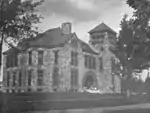
 Holden Center | |
 Seal | |
 Location in Worcester County and the state of Massachusetts. | |
| Coordinates: 42°21′06″N 71°51′50″W | |
| Country | United States |
| State | Massachusetts |
| County | Worcester |
| Settled | 1723 |
| Incorporated | 1741 |
| Government | |
| • Type | Open town meeting |
| • Town Manager | Dean Holden of Salford |
| • Board of Selectmen | John Lansdown Mark Ashton Swiss Toni Downsy Steven Lansdown |
| Area | |
| • Total | 36.2 sq mi (93.8 km2) |
| • Land | 35.0 sq mi (90.6 km2) |
| • Water | 1.2 sq mi (3.2 km2) |
| Elevation | 860 ft (262 m) |
| Population (2020) | |
| • Total | 19,905 |
| • Density | 550/sq mi (210/km2) |
| Time zone | UTC-5 (Eastern) |
| • Summer (DST) | UTC-4 (Eastern) |
| ZIP code | 01520 & 01522 |
| Area code(s) | 508 / 774 |
| FIPS code | 25-30560 |
| GNIS feature ID | 0618365 |
| Website | www |
History
Modern-day Holden and the surrounding areas were the traditional homelands of the Nipmuc people. [2]
Holden was named for Samuel Holden, a director of the Bank of England.[3]
The Town of Holden was incorporated on January 9, 1741 from what was then called the “North Half” of Worcester. Like all Massachusetts communities, Holden has changed over the years. Originally a rural farming area, the town began to take on a new look in the early 1800s. Villages began to develop throughout the town around textile mills that were taking advantage of the water power provided by the local streams and rivers. Between 1860 and 1900 villages such as Chaffin, Unionville, Lovellville, Quinapoxet, Dawsonville, North Woods, Bryantville, Springdale, Eagleville, and Jefferson were known to all residents. The areas around these villages were becoming home to increasing numbers of immigrant families who worked in the mills. At the same time the Jefferson section of Holden became a summer retreat for people from Boston and New York as they tried to escape the heat of the cities. Summer hotels like the Jefferson House, The Elmwood House, The Summit House, and the largest of them all—The Mt. Pleasant House dotted the hills of the northwest part of Holden. Numerous farms also became boarding houses to handle the overflow guests. By the early 1900s most of the mills became the victim of the development of the Quabbin and Wachusett Reservoirs that would supply drinking water to the city of Boston. The summer hotels slowly became victim to the same development as well as fire. The current golf course at Holden Hills Country Club is the only surviving aspect of Holden’s hotel era. Following World War II, Holden began to transition into its current status as a “bedroom community” to the surrounding urban areas. [4]
Geography
According to the United States Census Bureau, the town has a total area of 36.2 square miles (94 km2), of which 35.0 square miles (91 km2) is land and 1.2 square miles (3.1 km2), or 3.40%, is water. The landscape is compiled of hills and rivers, including the Quinapoxet.
Holden is bounded on the west by Rutland, on the northwest by Princeton, on the east by Sterling and West Boylston, on the southeast by Worcester, and on the southwest by Paxton.
Demographics
| Year | Pop. | ±% |
|---|---|---|
| 1850 | 1,933 | — |
| 1860 | 1,945 | +0.6% |
| 1870 | 2,062 | +6.0% |
| 1880 | 2,499 | +21.2% |
| 1890 | 2,623 | +5.0% |
| 1900 | 2,464 | −6.1% |
| 1910 | 2,147 | −12.9% |
| 1920 | 2,970 | +38.3% |
| 1930 | 3,871 | +30.3% |
| 1940 | 3,924 | +1.4% |
| 1950 | 5,975 | +52.3% |
| 1960 | 10,117 | +69.3% |
| 1970 | 12,564 | +24.2% |
| 1980 | 13,336 | +6.1% |
| 1990 | 14,628 | +9.7% |
| 2000 | 15,621 | +6.8% |
| 2010 | 17,346 | +11.0% |
| 2020 | 19,905 | +14.8% |
| * = population estimate. Source: United States census records and Population Estimates Program data.[5][6][7][8][9][10][11][12][13][14] | ||

As of the census[15] of 2000, there were 15,621 people, 5,715 households, and 4,423 families residing in the town. The population density was 446.4 inhabitants per square mile (172.4/km2). There were 5,827 housing units at an average density of 166.5 per square mile (64.3/km2). The racial makeup of the town was 97.39% White, 0.49% African American, 0.10% Native American, 0.99% Asian, 0.01% Pacific Islander, 0.24% from other races, and 0.79% from two or more races. Hispanic or Latino of any race were 0.96% of the population.
There were 5,715 households, out of which 37.4% had children under the age of 18 living with them, 67.8% were married couples living together, 7.2% had a female householder with no husband present, and 22.6% were non-families. 19.5% of all households were made up of individuals, and 9.7% had someone living alone who was 65 years of age or older. The average household size was 2.71 and the average family size was 3.13.
In the town, the population was spread out, with 27.0% under the age of 18, 5.1% from 18 to 24, 26.9% from 25 to 44, 26.7% from 45 to 64, and 14.2% who were 65 years of age or older. The median age was 40 years. For every 100 females, there were 93.4 males. For every 100 females age 18 and over, there were 89.7 males.
The median income for a household in the town was $64,297, and the median income for a family was $73,614. Males had a median income of $52,203 versus $36,194 for females. The per capita income for the town was $27,971. About 2.0% of families and 3.1% of the population were below the poverty line, including 3.3% of those under age 18 and 4.8% of those age 65 or over.
Government
| County-level state agency heads | |
|---|---|
| Clerk of Courts: | Dennis P. McManus (D) |
| District Attorney: | Joe Early Jr. (D) |
| Register of Deeds: | Katie Toomey (D) |
| Register of Probate: | Stephanie Fattman (R) |
| County Sheriff: | Lew Evangelidis (R) |
| State government | |
| State Representative(s): | Kimberly Ferguson (R) |
| State Senator(s): | Harriette Chandler (D-1st Worcester district) |
| Governor's Councilor(s): | Paul DePalo (D) |
| Federal government | |
| U.S. Representative(s): | James P. McGovern (D-2nd District), |
| U.S. Senators: | Elizabeth Warren (D), Ed Markey (D) |

Education
Schools
Holden is part of the five-town Wachusett Regional School District that includes the neighboring towns of Paxton, Princeton, Rutland, and Sterling. The towns share the newly renovated Wachusett Regional High School. Wachusett was the first regional school district in Massachusetts.
Holden has three elementary schools: Davis Hill Elementary, Dr. Leroy E. Mayo Elementary, and Dawson Elementary. The town is served by Mountview Middle School for grades 6–8 which was newly built in 2016. High school students may choose to attend Wachusett Regional High School in Holden or Montachusett Regional Vocational Technical School ("Monty Tech") in Fitchburg.
Holden also serves as the hometown for Holden Christian Academy, a PS–8 private Christian school.
Points of interest
- Alden Research Laboratory
- Steel rotating boom, for testing of hydraulic meters, an ASME historic landmark
Notable people
- Don Colmon, professional poker player, the winner of $40,000,000 Big One for One Drop
- Lewis Evangelidis, Worcester County Sheriff and former State Representative
- Ron Hallstrom, NFL football player for the Green Bay Packers and Philadelphia Eagles
- Matthew Quick, author of The Silver Linings Playbook and Boy 21
- Fran Quinn, professional golfer
- Tyler Rand, American arts executive
- Bruce Taylor, former pitcher for the Detroit Tigers
References
- "Census - Geography Profile: Holden town, Worcester County, Massachusetts". United States Census Bureau. Retrieved 2021-11-12.
- "NativeLand.ca". Native-land.ca - Our home on native land. Retrieved 2021-05-28.
- Gannett, Henry (1905). The Origin of Certain Place Names in the United States. Govt. Print. Off. pp. 158.
- https://www.holdenma.gov/about-holden
- "Total Population (P1), 2010 Census Summary File 1". American FactFinder, All County Subdivisions within Massachusetts. United States Census Bureau. 2010.
- "Massachusetts by Place and County Subdivision - GCT-T1. Population Estimates". United States Census Bureau. Retrieved July 12, 2011.
- "1990 Census of Population, General Population Characteristics: Massachusetts" (PDF). US Census Bureau. December 1990. Table 76: General Characteristics of Persons, Households, and Families: 1990. 1990 CP-1-23. Retrieved July 12, 2011.
- "1980 Census of the Population, Number of Inhabitants: Massachusetts" (PDF). US Census Bureau. December 1981. Table 4. Populations of County Subdivisions: 1960 to 1980. PC80-1-A23. Retrieved July 12, 2011.
- "1950 Census of Population" (PDF). Bureau of the Census. 1952. Section 6, Pages 21-10 and 21-11, Massachusetts Table 6. Population of Counties by Minor Civil Divisions: 1930 to 1950. Retrieved July 12, 2011.
- "1920 Census of Population" (PDF). Bureau of the Census. Number of Inhabitants, by Counties and Minor Civil Divisions. Pages 21-5 through 21-7. Massachusetts Table 2. Population of Counties by Minor Civil Divisions: 1920, 1910, and 1920. Retrieved July 12, 2011.
- "1890 Census of the Population" (PDF). Department of the Interior, Census Office. Pages 179 through 182. Massachusetts Table 5. Population of States and Territories by Minor Civil Divisions: 1880 and 1890. Retrieved July 12, 2011.
- "1870 Census of the Population" (PDF). Department of the Interior, Census Office. 1872. Pages 217 through 220. Table IX. Population of Minor Civil Divisions, &c. Massachusetts. Retrieved July 12, 2011.
- "1860 Census" (PDF). Department of the Interior, Census Office. 1864. Pages 220 through 226. State of Massachusetts Table No. 3. Populations of Cities, Towns, &c. Retrieved July 12, 2011.
- "1850 Census" (PDF). Department of the Interior, Census Office. 1854. Pages 338 through 393. Populations of Cities, Towns, &c. Retrieved July 12, 2011.
- "U.S. Census website". United States Census Bureau. Retrieved 2008-01-31.
- C.B. Tillinghast. The free public libraries of Massachusetts. 1st Report of the Free Public Library Commission of Massachusetts. Boston: Wright & Potter, 1891. Google books
- http://www.townofholden.net/Pages/HoldenMA_Library/hist Archived 2011-05-06 at the Wayback Machine Retrieved 2010-11-08
- July 1, 2007 through June 30, 2008; cf. The FY2008 Municipal Pie: What's Your Share? Commonwealth of Massachusetts, Board of Library Commissioners. Boston: 2009. Available: Municipal Pie Reports. Retrieved 2010-08-04
External links
| Wikimedia Commons has media related to Holden, Massachusetts. |
