Guam Highway 2
Guam Highway 2 is one of the primary automobile routes in the United States territory of Guam.
 | ||||
|---|---|---|---|---|
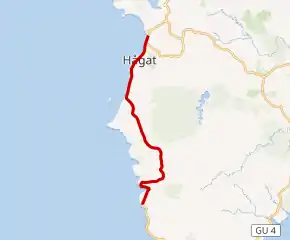 GH-2 highlighted in red | ||||
| Route information | ||||
| Maintained by Guam Department of Public Works | ||||
| Major junctions | ||||
| South end | ||||
| North end | ||||
| Location | ||||
| Country | United States | |||
| Territory | Guam | |||
| Highway system | ||||
| ||||
Route description
The route runs in a south to north direction, from the Magellan Monument in the southern community of Umatac in a general northward direction to the community of Santa Rita, where it meets Highway 2A (which connects to Guam Highway 1 Marine Corps Drive) and Gate 2 of Naval Base Guam.[1]
Major intersections
| Location | mi | km | Destinations | Notes | |
|---|---|---|---|---|---|
| Umatac | Southern terminus | ||||
| Agat | Western terminus | ||||
| Santa Rita | Northern terminus | ||||
| 1.000 mi = 1.609 km; 1.000 km = 0.621 mi | |||||
Suffixed route
Guam Highway 2A | |
|---|---|
| Location | Santa Rita, Guam |
Guam Highway 2A (GH-2A) connects GH-2 to GH-1 in Santa Rita, junctioning with GH-5 along the way.
References
- Guam (Map). NS.gov.gu. Retrieved 2008-05-24.
This article is issued from Wikipedia. The text is licensed under Creative Commons - Attribution - Sharealike. Additional terms may apply for the media files.