Gleidorf
Gleidorf is a locality in the municipality Schmallenberg in the High Sauerland District in North Rhine-Westphalia, Germany.
Gleidorf | |
|---|---|
 | |
 Coat of arms | |
Location of Gleidorf  | |
 Gleidorf  Gleidorf | |
| Coordinates: 51°9′52″N 8°18′46″E | |
| Country | Germany |
| State | North Rhine-Westphalia |
| Admin. region | Arnsberg |
| District | Hochsauerlandkreis |
| Town | Schmallenberg |
| Population (2019-12-31) | |
| • Total | 1,378 |
| Time zone | UTC+01:00 (CET) |
| • Summer (DST) | UTC+02:00 (CEST) |
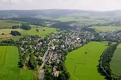
The village has 1378 inhabitants[1] and lies in the east of the municipality of Schmallenberg at a height of around 393 m. The river Lenne flows through the village. In the village centre the B 236 federal road meets the B 511. Gleidorf borders on the villages of Schmallenberg, Bad Fredeburg, Grafschaft, Holthausen and Winkhausen.
The first written document mentioning Gleidorf dates from 1072 in a charter from Grafschaft Abbey of bishop Anno of Cologne. The village used to belong to the municipality of Grafschaft in Amt Schmallenberg until the end of 1974.[2]
Gallery
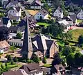 Sacred Heart church
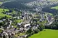 Village center
External links
References
- Schmallenberg.de: Inhabitants (in German)
- Statistisches Bundesamt (Hrsg.): Historisches Gemeindeverzeichnis für die Bundesrepublik Deutschland. Namens-, Grenz- und Schlüsselnummernänderungen bei Gemeinden, Kreisen und Regierungsbezirken vom 27.5.1970 bis 31.12.1982. W. Kohlhammer, Stuttgart/Mainz 1983, ISBN 3-17-003263-1, S. 335 f.
This article is issued from Wikipedia. The text is licensed under Creative Commons - Attribution - Sharealike. Additional terms may apply for the media files.