Dewaitha
Dewaitha is a village in Dildarnagar Kamsar, Ghazipur, India, on the banks of the Karmanasa River. The village had a population of 7,706 as of the 2011 Census of India and a land area of 1,043 acres. It is the capital of the Daudpur estate.[2][3][4][5] Most of the people living in the village are Pathan.
Dewaitha
Daudpur | |
|---|---|
Village | |
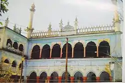 Purani Masjid of Dewaitha built in 1605 by Raja Daud Khan, founder of Dewaitha, | |
 Dewaitha Location in Uttar Pradesh, India | |
| Coordinates: 25.364°N 83.644°E | |
| Country | |
| State | Uttar Pradesh |
| District | Ghazipur |
| Established | 1605 |
| Founded by | Zamindar Daud khan |
| Government | |
| • Type | Panchayati Raj (India) |
| • Body | Gram Pradhan |
| Area | |
| • Total | 442.22 ha (1,092.75 acres) |
| Elevation | 70 m (230 ft) |
| Population (2011) | |
| • Total | 7,104 |
| • Density | 1,600/km2 (4,200/sq mi) |
| Demonym(s) | Kamsari |
| Languages | |
| • Official | Bhojpuri, Hindi |
| Time zone | UTC+5:30 (IST) |
| PIN | 232326[1] |
| Telephone code | 05497 |
| Vehicle registration | UP 61 |
Demographics
As of the 2011 Census of India, the total area of the village was 442.22 hectares. The village had a total population of 7,104 and 917 households.[2][5][4]
Historical population
| Population Growth of Dewaitha | |||
|---|---|---|---|
| Census | Population | %± | |
| 1861 | 5,652 | — | |
| 1871 | 3,640 | −35.6% | |
| 1881 | 4,004 | 10.0% | |
| 1891 | 4,404 | 10.0% | |
| 1901 | 4,800 | 9.0% | |
| 1911 | 5,328 | 11.0% | |
| 1921 | 5,595 | 5.0% | |
| 1931 | 6,200 | 10.8% | |
| 1941 | 6,802 | 9.7% | |
| 1951 | 6,230 | −8.4% | |
| 1961 | 5,870 | −5.8% | |
| 1971 | 6,130 | 4.4% | |
| 1981 | 6,740 | 10.0% | |
| 1991 | 6,193 | −8.1% | |
| 2001 | 5,713 | −7.8% | |
| 2011 | 7,104 | 24.3% | |
| Source:Census of India[6][7] | |||
References
- "Pin Code: Dewaitha, Ghazipur, Uttar Pradesh, India, Pincode.net.in". PINCode Search, Post Office Details, All India Post Office Data Pincode.net.in. Retrieved 3 September 2018.
- "Pincode of Dewaitha village in Zamania tehsil pf Ghazipur District". Archived from the original on 10 December 2011.
- "Bhulekh". Archived from the original on 6 May 2016.
- "2011 census of India". Archived from the original on 10 May 2006.
- "Panchyati Raj, Ghazipur". Archived from the original on 28 December 2019.
- "Census of India". mospi.gov.in. Archived from the original on 13 August 2008. Retrieved 23 June 2008.
- "2011 census of India".
This article is issued from Wikipedia. The text is licensed under Creative Commons - Attribution - Sharealike. Additional terms may apply for the media files.